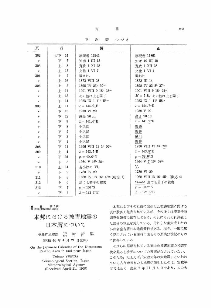
11 0 0 0 OA 本邦における被害地震の日本暦について
- 著者
- 湯村 哲男
- 出版者
- 公益社団法人 日本地震学会
- 雑誌
- 地震 第2輯 (ISSN:00371114)
- 巻号頁・発行日
- vol.22, no.3, pp.253-255, 1969-11-30 (Released:2011-03-08)
1 0 0 0 日本付近における地震帯の構造について
- 著者
- 湯村 哲男 広野 卓蔵 和達 清夫
- 出版者
- 公益社団法人 日本地震学会
- 雑誌
- 地震 第2輯 (ISSN:00371114)
- 巻号頁・発行日
- vol.23, no.2, pp.99-121, 1970
Spatial distribution of earthquake foci for the period from 1926 to 1968 in and near Japan were expressed in 16 maps each for a layer of 20-40km in thickness lying between 0 to 600km in depth. The maps show definitely the boundary lines and centers of local activities distinguishable in seismicity from each other. We named them seismic blocks. The centers of the shallow seismic blocks which crowd in a zone along the west side of the Japan trench can be traced down to 600km in depth. At first such centers move with increasing depth toward two junction areas of the island arcs of Kuril, NE-Japan and Izu-Bonin, that is, the Hokkaido and the Kwanto districts. From there they continue sinking to north for Hokkaido and to west for Kwanto making a dipping angle of 30°. Then their directions change abruptly by 90° at a depth of about 300km. From North Hokkaido one branch of the locus of the center goes into the Okhotsk Sea and the other into the Japan Sea along the coast of Primorye. On the other hand, the locus of the block center moving toward the west Kwanto turns to the south at that depth under Gifu Pref. for the Shikoku Basin, although a shorter branch goes northward into the Japan Sea. It is notable that few deep shocks occur in the middle of the Japan Sea. Considering the other geophysical and geological phenomena such as (1) the negative zone of isostatic anomaly of gravity lying along the Japan trench branches out to the junction areas in land, (2) the movement of the triangulation stations for the last 60 years or so amounts to about 3m to the north at Aomori Pref. in comparison with the Kui Peninsula, showing that two forces are acting in the respective areas in opposite directions, (3) the axis of mountain ranges made of metamorphic rocks which encounter the locus of the block center in Hokkaido and Central Honshu underwent severer bending, we conclude that the locus of the seismic block center expresses the location of the mantle current coming from the Pacific. itself.
1 0 0 0 OA 日本付近における地震帯の構造について
- 著者
- 湯村 哲男 広野 卓蔵 和達 清夫
- 出版者
- 公益社団法人 日本地震学会
- 雑誌
- 地震 第2輯 (ISSN:00371114)
- 巻号頁・発行日
- vol.23, no.2, pp.99-121, 1970-06-28 (Released:2010-03-11)
- 参考文献数
- 18
Spatial distribution of earthquake foci for the period from 1926 to 1968 in and near Japan were expressed in 16 maps each for a layer of 20-40km in thickness lying between 0 to 600km in depth. The maps show definitely the boundary lines and centers of local activities distinguishable in seismicity from each other. We named them seismic blocks. The centers of the shallow seismic blocks which crowd in a zone along the west side of the Japan trench can be traced down to 600km in depth. At first such centers move with increasing depth toward two junction areas of the island arcs of Kuril, NE-Japan and Izu-Bonin, that is, the Hokkaido and the Kwanto districts. From there they continue sinking to north for Hokkaido and to west for Kwanto making a dipping angle of 30°. Then their directions change abruptly by 90° at a depth of about 300km. From North Hokkaido one branch of the locus of the center goes into the Okhotsk Sea and the other into the Japan Sea along the coast of Primorye. On the other hand, the locus of the block center moving toward the west Kwanto turns to the south at that depth under Gifu Pref. for the Shikoku Basin, although a shorter branch goes northward into the Japan Sea. It is notable that few deep shocks occur in the middle of the Japan Sea. Considering the other geophysical and geological phenomena such as (1) the negative zone of isostatic anomaly of gravity lying along the Japan trench branches out to the junction areas in land, (2) the movement of the triangulation stations for the last 60 years or so amounts to about 3m to the north at Aomori Pref. in comparison with the Kui Peninsula, showing that two forces are acting in the respective areas in opposite directions, (3) the axis of mountain ranges made of metamorphic rocks which encounter the locus of the block center in Hokkaido and Central Honshu underwent severer bending, we conclude that the locus of the seismic block center expresses the location of the mantle current coming from the Pacific. itself.
