4 0 0 0 OA 秋田県・千屋断層の陸羽地震断層露頭の発見
- 著者
- 今泉 俊文 楮原 京子 大槻 憲四郎 三輪 敦志 小坂 英輝 野原 壯
- 出版者
- The Association of Japanese Geographers
- 雑誌
- 日本地理学会発表要旨集
- 巻号頁・発行日
- pp.5, 2006 (Released:2006-05-18)
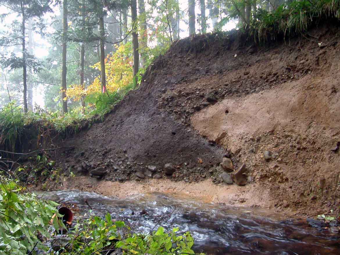
1.はじめに 陸羽地震(1896年)は,千屋断層が引き起こした典型的な逆断層タイプの地震であり,世界的に見ても歴史地震としては数少ない逆断層の例の一つである.これまで本断層を対象に地形・地質調査,トレンチ調査,反射法地震探査・重力探査等いろいろな調査研究がおこなわれてきた.演者らは,千屋丘陵の西麓・花岡で,陸羽地震時の断層露頭を発見した.地表トレースが地形境界に沿って湾曲することが明確になり,逆断層の先端(地表)から地下に至る断層の形状・構造が複雑であることがわかった,その形成過程とあわせて検討することが必要である.2.断層線 花岡・大道川(菩提沢)の河岸において断層露頭を発見した.この場所は,千屋丘陵西麓(断層崖)から300m程山側(東側)に入り込んだ沖積扇状地の扇頂付近にあたる.露頭の標高は,丘陵前面の断層崖基部に比べて高い.つまり,断層線は地形境界に沿うように湾曲する(図1).松田ほか(1980)は,花岡では断層が扇央を通過すると考えていたが,地籍図・土地台帳図の解釈からは,山際を通過することが指摘されていた(今泉・稲庭,1983).このような崖線の湾曲は,逆断層の特徴でもある.中小森のトレンチ調査現場(天然記念物保存地)の小谷で行われたボーリング調査結果から,このような断層線の湾曲は,地表近くで断層の走向または傾斜が変化(地下から地表に向かって雁行)することによって生じると考えた(今泉ほか,1986).花岡の谷(大道川)は.千屋丘陵の開析谷では谷幅も広い.谷幅に応じて湾入の程度が変わるとすれば,断層面の形状の変化も,谷幅に比例した深度から生じていると考えるべきだろう.この露頭の脇を通って(せせらぎ公園のある沢沿い),1996年に活断層を横切る反射法地震探査がはじめて実施され,千屋断層がemergent thrustであることや,この断層に沿って断層上盤側が東側へ傾動する構造などが明らかにされた(佐藤ほか,1998). 逆断層露頭を直接観察できる地点(一丈木・赤倉川河岸など)や,明瞭な地震断層崖が連続する場所は,千屋丘陵の麓でも,大局は断層線がほぼ北北東〓南南西走向を示す区間である.これに対して,走向が変わる千屋丘陵北端部や南端部では,断層上盤は撓曲変形を示し,陸羽地震時の断層の詳細な位置や変位量は不確かである.北端部や南端部では,逆向き断層を含めた副次的な断層によって,上盤側に数列の背斜状の高まりが生じている.3.断層露頭 上盤側の新第三紀層と段丘堆積物が下盤側の地震前の地表に衝上(傾斜は約30度)して.そこに崖高1.2m程の低断層崖を形成している(崖の上にはかつて小規模な発電所があった).断層に沿っては,砂礫層の回転・引きずりが明瞭である.この地形面(砂礫層の堆積の)年代を知るために年代を測定中である.あわせてこの露頭から陸羽地震以前の活動についても(その時期も含めて)詳細を検討中である.
1 0 0 0 OA 震源断層となりうる活断層とリニアメントの検討-中国地方を事例として-
- 著者
- 高田 圭太 中田 高 野原 壯 原口 強 池田 安隆 伊藤 潔 今泉 俊文 大槻 憲四郎 鷺谷 威 堤 浩之
- 出版者
- 一般社団法人 日本活断層学会
- 雑誌
- 活断層研究 (ISSN:09181024)
- 巻号頁・発行日
- vol.2003, no.23, pp.77-91, 2003-06-30 (Released:2012-11-13)
- 参考文献数
- 28
Large inland earthquakes bigger than Mj 7.2 during the historical past on Japanese islands have mostly been generated from active faults (Matsuda,1998). The 2000 Tottoriken-seibu earthquake of Mj 7.3 (Mw 6.6), however, occurred in the area where distinctive active faults were not mapped before the earthquake, and the surface ruptures associated with the earthquake were small and sparse. Active faults are hardly recognized even by detailed interpretation of aerial photographs after the earthquake but sharp lineaments. In Chugoku district in southwest Japan is characterized by less densely-distributed active faults with lower activities than other areas in Japan, and the 1943 Tottori earthquake of M 7 occurred by reactivation of the Shikano fault with rather obscure fault traces.Taking this condition, in mind, we carried out detailed mapping of active faults and lineaments, and compared with their topographical, geological, seismological and tectonic settings, in order to develop a new technique to find potential seismogenic faults.The results obtained are as follows;1) Active faults and lineaments were not evenly distributed, and the dense zone is recognized along the Japan Sea while the sparse zone in the central part of the district. The active faults known before are mainly located in the dense zone (Fig.1).2) The lineaments mapped are mostly less than 10km long, and half of them strike to NE-SW or ENE-WSW and 30 per cent to NW-SE or WNW-ESE (Fig.2). NE-SW lineaments prevail in the western part of the district, and NW-SW lineaments are systematically distributed only in the western-most and eastern-most area of the district probably reflecting their tectonic setting under the present stress condition.3) Lineaments with poor topographical manifest were not commonly recognized by individual geologist, and were generally short, scattered, isolated, random in strike, and independent from geological structures. These lineaments will not be considered as potential seismogenic faults.4) Epicenters of the small earthquakes are characteristically distributed to the north of the backbone range probably coincided with the past volcanic front. On the contrary, the area to the south of the backbone range the seismicity is sparse, except for several swarms. These seismic condition well matches with the distribution of active faults and well-defined lineaments (Fig.3).5) Most of the active faults and lineaments follow the pre-existed geological faults that had moved opposite direction to the active faulting, indicating their inversion movements under the present stress field.6) Surface ruptures reported as earthquake faults associated with the 2000 Tottoriken-seibu earthquake are considered as results of subsidiary shallow-sheeted faulting spontaneously caused by stain release around the seismogenic faulting in depth, because many of them appeared spontaneously, and not always along rather well-defined lineaments. They are small in extent and displacement. Therefore, it is rather difficult for evaluate such minor surface fault ruptures, but such ruptures may not displace the surface in large extent.
1 0 0 0 活断層GISデータを用いた地殻の歪速度の推定
The horizontal strain rate caused by fault activity for the past several hundred thousand years was calculated using the latest active fault database. Features of fault activity at the scale of the Japanese Islands were estimated, and the results were compared with the strain rates that the pre-existing literature showed.<BR>The strain rate required using the latest active fault database resembles the strain rate requ ired using the pre-existing data on active faults in the Quaternary period (Kaizuka and Imaizumi,1984). The distribution of the strain rate required from active fault data resembles the distribution of the strain rate required from the GPS observations (Sagiya<I>et al</I>.,1999) in many regions, with the exception of the Pacific coast region. However the value of strain rate required from active faults data (10<SUP>-8</SUP>/year) is smaller than the value of strain rate required from the GPS data (10<SUP>-7</SUP>/year). In the region along the Ou Mountains, Northeast Japan, the value of strain rate required from the latest active fault data was nearly equal to the strain rate required from the geological section (Sato,1989).
