16 0 0 0 OA 地図にみられる日本とアイヌの河川・湖沼・湿地の地名
- 著者
- 中平 龍二郎
- 出版者
- Japan Cartographers Association
- 雑誌
- 地図 (ISSN:00094897)
- 巻号頁・発行日
- vol.13, no.3, pp.31-40, 1975-09-30 (Released:2011-07-19)
16 0 0 0 OA 伊能図中図におけるずれに関する考察
- 著者
- 金澤 敬
- 出版者
- Japan Cartographers Association
- 雑誌
- 地図 (ISSN:00094897)
- 巻号頁・発行日
- vol.38, no.1, pp.13-20, 2000-03-30 (Released:2011-07-19)
- 参考文献数
- 16
12 0 0 0 OA 火山ハザードマップの読み取りに対するドリルマップ提示の効果
- 著者
- 村越 真 小山 真人
- 出版者
- Japan Cartographers Association
- 雑誌
- 地図 (ISSN:00094897)
- 巻号頁・発行日
- vol.45, no.4, pp.1-11, 2007-12-31 (Released:2011-07-19)
- 参考文献数
- 13
- 被引用文献数
- 1
From two experiments, effect of drill map presentation for reading task of hazard map was examined. Two experiments were conducted to determine whether providing specialized projected volcanic activity maps (drill maps) resulted in improved interpretation of publicly available volcanic hazard maps.In the first experiment, 113 junior high school students and 33 university students were required to formulate a plan of action in the event of a volcanic activity alert working in pairs. This task was carried out by two groups of participants: an experimental group and a control group. For the experimental group, a drill map showing projected lava flows from three different volcanic craters was presented before the task. The participants also filled out a questionnaire regarding their level of knowledge about volcanic hazards and their impressions about the task. Although no difference in performance was discernable in relation to the questionnaire responses, the general quality of plans produced by the experimental group was better than the control group.In the second experiment the task, carried outindividually, was to evaluate the urgency to evacuate at six different locations shown on a hazard map under three different hypothetical situations: 1) a volcanic activity advisory, 2) volcanic activity alert with an assumed crater location, and 3) volcanic activity alert with a different assumed crater location. Forty-two university students were randomly assigned to either the control group or the experimental group. The experimental group participants were presented with a drill map and given an explanation of the drill map. The same task was also given to ten experts on volcanic activity. The evaluation of the threat was significantly different a one location (location E) between situation 2 and 3 in the control group while at three locations (A, C, & D) in the experimental group and at two locations (location A & D) in the expert group. Also, a comparison between the three groups showed that the evaluations of the experimental group were similar to those of the experts. This indicates that presentation of drill maps enables adults with no special knowledge about hazard maps to evaluate the urgency of the threat due to volcanic activities more accurately from hazard maps.
11 0 0 0 OA 海峡地形の呼称について
- 著者
- 中西 良夫
- 出版者
- Japan Cartographers Association
- 雑誌
- 地図 (ISSN:00094897)
- 巻号頁・発行日
- vol.1, no.4, pp.18-22, 1963-12-31 (Released:2011-07-19)
8 0 0 0 OA 江戸時代作製の張抜き地形模型『防長土図』
- 著者
- 三浦 肇 川村 博忠
- 出版者
- Japan Cartographers Association
- 雑誌
- 地図 (ISSN:00094897)
- 巻号頁・発行日
- vol.20, no.2, pp.20-26, 1982-06-30 (Released:2011-07-19)
- 参考文献数
- 5
7 0 0 0 OA 新潟市の市街地拡大過程と都市計画
- 著者
- 高津 斌彰
- 出版者
- Japan Cartographers Association
- 雑誌
- 地図 (ISSN:00094897)
- 巻号頁・発行日
- vol.13, no.4, pp.1-7, 1975-12-01 (Released:2011-07-19)
- 参考文献数
- 2
7 0 0 0 OA 地形図上に表現された鉄道
- 著者
- 清水 靖夫
- 出版者
- Japan Cartographers Association
- 雑誌
- 地図 (ISSN:00094897)
- 巻号頁・発行日
- vol.33, no.3, pp.35-40, 1995-09-30 (Released:2011-07-19)
- 参考文献数
- 8
6 0 0 0 OA 地図と空間認知をめぐる理論的・応用的諸問題
- 著者
- 若林 芳樹 鈴木 晃志郎
- 出版者
- Japan Cartographers Association
- 雑誌
- 地図 (ISSN:00094897)
- 巻号頁・発行日
- vol.41, no.4, pp.3-16, 2003-12-28 (Released:2011-07-19)
- 参考文献数
- 107
- 被引用文献数
- 1
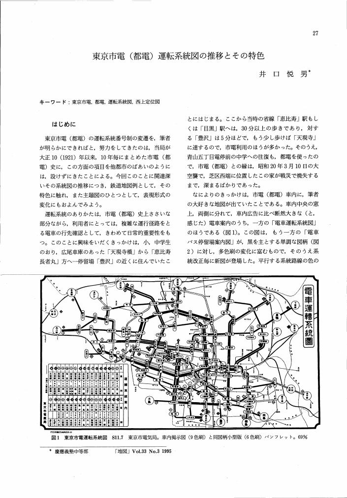
6 0 0 0 OA 東京市電 (都電) 運転系統図の推移とその特色
- 著者
- 井口 悦男
- 出版者
- Japan Cartographers Association
- 雑誌
- 地図 (ISSN:00094897)
- 巻号頁・発行日
- vol.33, no.3, pp.27-34, 1995-09-30 (Released:2011-07-19)
- 参考文献数
- 2
6 0 0 0 OA 「鉄道旅行案内書」の地図
- 著者
- 中川 浩一
- 出版者
- Japan Cartographers Association
- 雑誌
- 地図 (ISSN:00094897)
- 巻号頁・発行日
- vol.33, no.3, pp.15-26, 1995-09-30 (Released:2011-07-19)
- 参考文献数
- 4
4 0 0 0 OA 北海道のアイヌ語地名における頻用語
- 著者
- 佐藤 典彦
- 出版者
- Japan Cartographers Association
- 雑誌
- 地図 (ISSN:00094897)
- 巻号頁・発行日
- vol.15, no.1, pp.11-20, 1977-03-31 (Released:2011-07-19)
- 参考文献数
- 14
4 0 0 0 OA 第一軍 (師) 管地方迅速測図・小地測量原図について
- 著者
- 師橋 辰夫
- 出版者
- Japan Cartographers Association
- 雑誌
- 地図 (ISSN:00094897)
- 巻号頁・発行日
- vol.12, no.1, pp.38-43, 1974-03-31 (Released:2011-07-19)
4 0 0 0 OA 地図投影法の定義と「投影」概念
- 著者
- 政春 尋志
- 出版者
- Japan Cartographers Association
- 雑誌
- 地図 (ISSN:00094897)
- 巻号頁・発行日
- vol.45, no.3, pp.1-15, 2007-09-30 (Released:2011-07-19)
- 参考文献数
- 41
- 被引用文献数
- 1
3 0 0 0 OA 日本近海における浅瀬の名称についての一考察
- 著者
- 跡部 治
- 出版者
- Japan Cartographers Association
- 雑誌
- 地図 (ISSN:00094897)
- 巻号頁・発行日
- vol.4, no.1, pp.29-33, 1966-03-25 (Released:2011-07-19)
3 0 0 0 地域的にみた横浜市の都市農業の方向:農業専用地区を調査して
- 著者
- 北村 清
- 出版者
- Japan Cartographers Association
- 雑誌
- 地図 (ISSN:00094897)
- 巻号頁・発行日
- vol.26, pp.10a-11, 1988
- 著者
- 平田 益美 金澤 敬 橋本 良一
- 出版者
- Japan Cartographers Association
- 雑誌
- 地図 (ISSN:00094897)
- 巻号頁・発行日
- vol.33, no.2, pp.48-53, 1995-06-30
3 0 0 0 OA 内務省地理局『東京実測全図』について
- 著者
- 清水 靖夫
- 出版者
- Japan Cartographers Association
- 雑誌
- 地図 (ISSN:00094897)
- 巻号頁・発行日
- vol.6, no.3, pp.1-6, 1968-09-30 (Released:2011-07-19)
- 参考文献数
- 5
3 0 0 0 OA 移動のための地図とその利用
- 著者
- 村越 真
- 出版者
- Japan Cartographers Association
- 雑誌
- 地図 (ISSN:00094897)
- 巻号頁・発行日
- vol.27, no.2, pp.1-8, 1989-06-30 (Released:2011-07-19)
- 参考文献数
- 13
2 0 0 0 OA 手描き地図を用いた空間認知研究へのGISの適用
- 著者
- 高井 寿文 奥貫 圭一 岡本 耕平
- 出版者
- Japan Cartographers Association
- 雑誌
- 地図 (ISSN:00094897)
- 巻号頁・発行日
- vol.41, no.4, pp.27-36, 2003-12-28 (Released:2011-07-19)
- 参考文献数
- 13
2 0 0 0 OA 明治初期の勇払基線と苫小牧の発展
- 著者
- 加藤 芳夫
- 出版者
- Japan Cartographers Association
- 雑誌
- 地図 (ISSN:00094897)
- 巻号頁・発行日
- vol.16, no.4, pp.11-16, 1978-12-10 (Released:2011-07-19)
本稿は, 第9回国際地図学会議 (53年7月, ワシントンD. Cメリーランド大学) のために, 国際地図情報センターから提出されたThe First Systematie Base-line and Triangulation Survey in Japan-Yufutsu Base-line Survey in Hokkaido in 1873-をもとに, この基線測量からすでに一世紀を経過した苫小牧の変遷を, 国土地理院の5万分の1地形図によって概観し, 特に戦後, 内陸堀込港湾の造成によって急速なテンポで変貌しているこの地域の様相を描いてみたい。本号の添付地図は, 明治8年開拓使による「三角術測量北海道之図」及び「北海道三角術測量有仏基線之図」であり, 同国際会議に提出したものと同様のものである。国際地図情報センターから筆者への要請は, アメリカで開かれる国際会議であるだけに, 日米の国際親善及び国際交流のための橋渡しの一助となればという意図によるものであった。従って, この古地図の複製にあたっても, 古地図としての歴史的な意義を解明することを目的とするものではなく, より一般的に明治初期の開拓使時代における偉大な事業のひとつとして紹介したものである。


