1 0 0 0 OA 日奈久断層北端部で確認された熊本地震の地表余効すべり
- 著者
- 遠田 晋次 鳥井 真之 小俣 雅志 三五 大輔 石澤 尭史
- 出版者
- 一般社団法人 日本活断層学会
- 雑誌
- 活断層研究 (ISSN:09181024)
- 巻号頁・発行日
- vol.2021, no.54, pp.39-56, 2021 (Released:2022-01-19)
- 参考文献数
- 39
Afterslip, mostly aseismic creep on and on the margins of the seismic source fault, occurs not only after a large subduction megathrust earthquake but also rarely on an onshore surface rupture such as the 1966 and 2004 Parkfield, California, earthquakes on the San Andreas fault. Here we present evidence for afterslip as post-seismic continuous creep along the part of the coseismic surface rupture of the 16 April 2016 Kumamoto earthquake of Mw 7.0 (MJMA 7.3). We describe evident surface afterslip on five sites along the northermost Hinagu fault that experienced 30-65 cm coseismic right-lateral slip. Even though the post-seismic tape measurements are not highly accurate and contains approximately±1-3 cm uncertainty depending on site condition, maximum right-lateral displacement have reached ~20 cm during the first one year after the mainshock. Additionally, up to 5-cm cumulative right-lateral slip of a wall newly built in February 2017 across the coseismic rupture proves that the post-seismic creep has been lasting for at least one year, probably longer than three years. Together with the field survey, we also mapped one-year postseismic ground displacement from analysis of interferometric synthetic aperture radar (InSAR) images. About 2.5 cm contraction across the Hinagu fault from InSAR is a little short but mostly consistent with ~3.5 cm contraction estimated from ~20 cm right-lateral post-seismic slip on the N10°E trending rupture zone. Furthermore, our field observation is also in agreement with the timeseries of horizontal movement of a GNSS station ~2 km southeast of the fault zone. To examine the contribution of local aftershocks to the afterslip, we examined the cumulative moment release of all the aftershocks that reached ~5.1 x 1024 dyne-cm. Assuming a 10 km by 10 km fault plane, one could expect ~16 cm slip that is roughly equivalent to the amount of measured surface afterslip. However, the numerous aftershocks are located probably off the subsurface Hinagu fault so that shallow aseismic creeping would play an essential role for surface afterslip. Although our field measurements, InSAR and aftershock analysis cannot simply judge that the afterslip has been continuously loading to the unruptured sections of the Hinagu fault zone, significant aftershock activity has been still occurring beyond the southern edge of the afterslip zone. The Hinagu afterslip gives us clues not only to understand the postseismic fault behavior but also how to prevent from postseismic damage of fault-crossing structures and better assess the timing of restoration.
1 0 0 0 OA 熊本県西原村布田における布田川断層の古地震調査
- 著者
- 石村 大輔 岩佐 佳哉 高橋 直也 田所 龍二 小田 龍平 梶井 宇宙 松風 潤 石澤 尭史 堤 浩之
- 雑誌
- JpGU-AGU Joint Meeting 2020
- 巻号頁・発行日
- 2020-03-13
2016年熊本地震以後に、布田川断層帯および日奈久断層帯において精力的に古地震調査が行われてきた。我々の研究グループでは、2016年熊本地震で出現した副次的な地表地震断層の過去の活動について明らかにするために、2017年には阿蘇カルデラ内の宮地トレンチ、2018年には出ノ口断層上の小森牧野トレンチを実施してきた。その結果、2-3千年という短い間隔で2016年に活動した断層が繰り返し活動していることが明らかとなった(石村ほか,2018,2019)。これは2016年熊本地震同様に、過去にも布田川断層の活動に際して、周辺の広い範囲に断層が出現したことを示唆する。一方、布田川断層の活動履歴については、多くのトレンチ調査が行われているが(熊原ほか,2017;岩佐ほか,2018;白濱ほか,2018;堤ほか,2018;上田ほか,2018,遠田ほか,2019,など)、それらの多くは鬼界―アカホヤ火山灰(7.3 ka;町田・新井,2003)以降に複数回活動したことを示すのみで、個々のイベントの年代が十分に制約できていない。また、トレンチ調査場所も、阿蘇カルデラ内や益城町に向かって分岐する断層上といった地点に偏っており、最も変位量の大きかった布田川断層の中央部に位置する布田周辺での活動履歴はよくわかっていない。そこで本研究では、布田川断層中央部に位置する布田地区でトレンチ調査を行なった。 掘削地点は、布田川断層と布田川が交わる西原村布田地区である。布田川断層と布田川が交わる地点では、2016年熊本地震で出現した大露頭の記載を石村(2019)が行なっており、高遊原溶岩を数10 m上下変位させる布田川断層の主断層と10 m前後上下変位させる副次的な断層が確認されている。そこから約50 mほど東の林内で5つのトレンチを掘削した。トレンチ掘削地点では、2条の地表地震断層が確認されており、南側のものは約10 cmの南落ちを伴う左ステップする開口亀裂、北側のものは30-40 cmの南落ちを示す断層崖であった。地表地震断層の変位様式と布田川の露頭で認められた断層との位置関係から、南側が主たる右横ずれ断層で、北側が副次的な正断層であると考えられる。トレンチは、南側で2箇所、北側で3箇所の掘削を行なった。 トレンチ調査の結果、すべての壁面で2016年の断層活動に加えて、過去の活動が認められた。特にK-Ah以降には少なくとも3回の断層活動(2016年イベント含む)が認められ、高い活動度を示した。現在、放射性炭素年代測定を実施中であり、発表ではそれらを加えて、より詳細な断層活動の議論とその時期について示す。
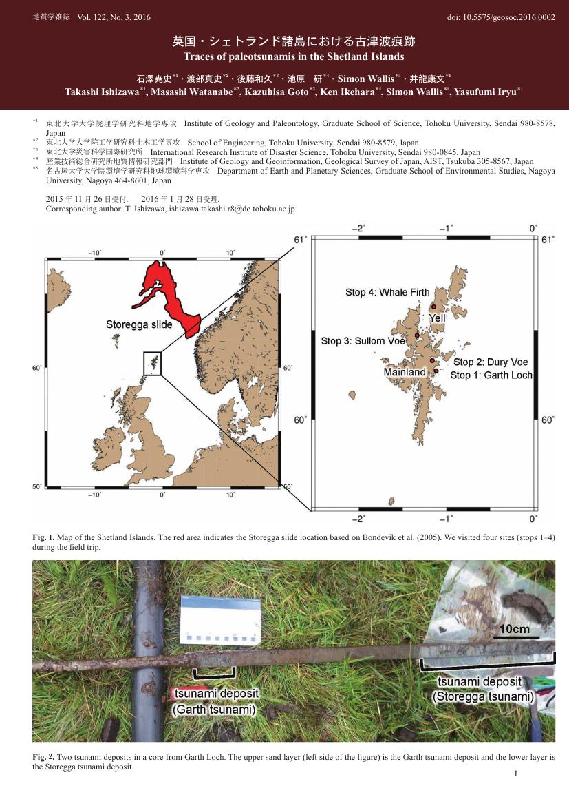
1 0 0 0 OA 英国・シェトランド諸島における古津波痕跡
- 著者
- 石澤 尭史 渡部 真史 後藤 和久 池原 研 Simon Wallis 井龍 康文
- 出版者
- 一般社団法人 日本地質学会
- 雑誌
- 地質学雑誌 (ISSN:00167630)
- 巻号頁・発行日
- vol.122, no.3, pp.I-II, 2016-03-15 (Released:2016-06-21)
- 参考文献数
- 2
