1 0 0 0 OA 「シリカ」傾斜計
- 著者
- 石本 巳四雄
- 出版者
- 公益社団法人 日本地震学会
- 雑誌
- 地震 第1輯 (ISSN:00371114)
- 巻号頁・発行日
- vol.1, no.1, pp.17-32, 1929-01-15 (Released:2010-11-17)
1 0 0 0 OA 地震に關係して重力は變化するか
- 著者
- 石本 巳四雄
- 出版者
- 公益社団法人 日本地震学会
- 雑誌
- 地震 第1輯 (ISSN:00371114)
- 巻号頁・発行日
- vol.1, no.4, pp.241-249, 1929-04-15 (Released:2010-11-17)
1 0 0 0 OA 日本古來の地震原因觀
- 著者
- 石本 巳四雄
- 出版者
- 公益社団法人 日本地震学会
- 雑誌
- 地震 第1輯 (ISSN:00371114)
- 巻号頁・発行日
- vol.3, no.1, pp.39-44, 1931-01-15 (Released:2010-11-17)
1 0 0 0 OA 地震強度觀測の必要
- 著者
- 石本 巳四雄
- 出版者
- 公益社団法人 日本地震学会
- 雑誌
- 地震 第1輯 (ISSN:00371114)
- 巻号頁・発行日
- vol.1, no.12, pp.877-888, 1929-12-15 (Released:2010-11-17)
1 0 0 0 OA 徳川時代に於ける地震學 (4)
- 著者
- 石本 巳四雄
- 出版者
- 公益社団法人 日本地震学会
- 雑誌
- 地震 第1輯 (ISSN:00371114)
- 巻号頁・発行日
- vol.9, no.6, pp.286-290_1, 1937-06-15 (Released:2010-03-09)
1 0 0 0 OA 地震計記象のレンズ倍率に就て
- 著者
- 石本 巳四雄
- 出版者
- 公益社団法人 日本地震学会
- 雑誌
- 地震 第1輯 (ISSN:00371114)
- 巻号頁・発行日
- vol.11, no.2, pp.53-56, 1939-02-25 (Released:2010-03-09)
- 参考文献数
- 3
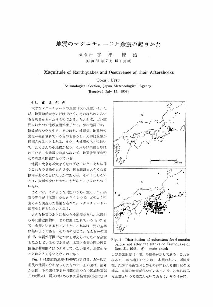
1 0 0 0 OA 地震のマグニチュードと余震の起りかた
- 著者
- 宇津 徳治
- 出版者
- 公益社団法人 日本地震学会
- 雑誌
- 地震 第2輯 (ISSN:00371114)
- 巻号頁・発行日
- vol.10, no.1, pp.35-45, 1957-08-25 (Released:2010-03-11)
- 被引用文献数
- 45
1 0 0 0 OA 南西諸島のGPS速度場とサイスモテクトニクス
- 著者
- 渡部 豪 田部井 隆雄
- 出版者
- 公益社団法人 日本地震学会
- 雑誌
- 地震 第2輯 (ISSN:00371114)
- 巻号頁・発行日
- vol.57, no.1, pp.1-10, 2004-08-25 (Released:2010-03-11)
- 参考文献数
- 23
- 被引用文献数
- 1 4
The Ryukyu Arc is a NE-SW trending island arc that connects southwest Japan and Taiwan. The Philippine Sea plate subducts at the Ryukyu Trench, the southeastern boundary of the Ryukyu Arc. While the plate model predicts a rather high subduction rate (60-80mm/yr), plate coupling has been estimated so small from the earthquake data. Another factor characterizing tectonic features of the region is an active backarc opening at the Okinawa Trough that forms the northwestern boundary of the region. Japanese nationwide continuous GPS array has illustrated a trenchward motion of the Ryukyu Arc. However, it is difficult to quantify the effects of the subduction and the backarc opening because there is little deployment of the GPS network in the direction perpendicular to the strikes of those two boundaries. To model tectonic movement of the region, at first we divide the region into four crustal blocks based on horizontal GPS velocities and geological conditions. As the first approximation, plate coupling is neglected. Crustal velocities predicted from the block motions are in good agreement with the observed ones with an average discrepancy of about 3mm/yr. Next, we introduce moment tensor data of shallow earthquakes to calculate crustal strain rates in several segments and further estimate spatial variation of the plate coupling. The results show that the estimated plate coupling is smaller than 10% in most segments except 50% in the northernmost part. We interpret that the plate coupling at the Ryukyu Trench is so small and the trench can behave as a free boundary. Thus if a backarc opening occurs at the Okinawa Trough, the Ryukyu Arc can easily move trenchward without significant internal deformation. However, detailed mechanism of the backarc opening remains still unknown and is an important problem to be resolved in the future.
1 0 0 0 OA STS-1型地震計の長期安定性に関する問題
- 著者
- 山田 功夫
- 出版者
- 公益社団法人 日本地震学会
- 雑誌
- 地震 第2輯 (ISSN:00371114)
- 巻号頁・発行日
- vol.53, no.3, pp.259-262, 2001-03-25 (Released:2010-03-11)
- 参考文献数
- 2
- 被引用文献数
- 1 2
1 0 0 0 OA 相模湾西部, 初島の完新世海成段丘と地殻上下変動
- 著者
- 石橋 克彦 太田 陽子 松田 時彦
- 出版者
- 公益社団法人 日本地震学会
- 雑誌
- 地震 第2輯 (ISSN:00371114)
- 巻号頁・発行日
- vol.35, no.2, pp.195-212, 1982-06-25 (Released:2010-03-11)
- 参考文献数
- 19
- 被引用文献数
- 1 1
Uplifted Holocene marine terraces of Hatsu-shima Island (0.44km2) in the western part of Sagami Bay on the Pacific coast of central Japan have been investigated with special reference to the late Quaternary seismic crustal movement of the island. Hatsu-shima Island, which is located at the top of the western steep scarp of the northernmost part of the Sagami trough, was uplifted almost uniformly by around 2m at the time of the 1923 Kanto earthquake (Ms=8.2).The whole surface of the island consists of a flight of marine terraces developed on Pliocene volcanics. These terraces are clearly classified into three groups; I, II, and III. Terrace I, the highest (about 50m asl), is distributed only in the southeastern small part of the island. Terrace II, 25-40m asl, is the widest in the island and tilting, generally, northwestward. Terraces I and II have been correlated to Obaradai Terrace of about 80, 000yrs B. P. in age and to Misaki Terrace of about 60, 000yrs B. P. in age, respectively, by SUGIHARA (1980) based on marker tephras covering the terraces.Terraces III, rather narrow but well defined especially in the northern and western parts of the island, is distributed along the present shoreline at the foot of a former sea cliff as high as about 20m surrounding Terrace II (or I in the southeastern part). In this paper they are subdivided into three; IIIa, IIIb, and IIIc. Terrace IIIa, the highest and widest among group III, is rather flat with about 10m asl inner margin. Planned excavation at three localities on this terrace has revealed that terrace deposits composed of marine gravel and sand of 1.5-2m thickness rest unconformably on rather weathered bed rock. Fossil shells that were obtained at the base of terrace deposits at Excavation B, which are judged to be in situ and to represent the terrace's age, have been dated at 6, 730±190 14C yrs B. P. (GaK-9080). From this 14C date, as well as from the topographical features, Terrace IIIa can be interpreted as the highest Holocene terrace formed about 6, 000 years ago (so-called Numa Terrace). The height of former shoreline is estimated at around 9m asl. Terraces IIIb and IIIc are narrow emergent shingle beach, whose inner margins are 6-7m asl and about 4m asl, respectively. IIIc includes the emergent beach of 1923 in its lowest part. Although the topographical separation between IIIb and IIIc is not necessarily clear, they can be distinguished from each other as IIIb surface is covered by dense vegetation including many pine trees which have been growing since before the 1923 coseismic uplift, whereas IIIc surface has no vegetation. Therefore, it is almost certain that at least two times of intermittent emergence had occurred between the formation of Terrace IIIa and the 1923 coseismic uplift. However, the dates of emergence have remained undefined, because 14C dates of fossil shells which were collected from Terraces IIIb and IIIc are so much scattered implying that the materials are not in situ. In the northern part of the island there is a prominent flat surface higher than Terrace IIIa, 10-15m asl, where Hatsu-shima village is situated. In this paper it is named IIIa' Surface and considered a secondary surface modified from Terrace IIIa by landslides of a back scarp and artificial alteration based on its sedimentological features, surrounding topographical features, and rather young 14C dates of materials obtained from this surface.
1 0 0 0 OA 遠地津波の数値計算に関する研究
- 著者
- 今村 文彦 首藤 伸夫 後藤 智明
- 出版者
- 公益社団法人 日本地震学会
- 雑誌
- 地震 第2輯 (ISSN:00371114)
- 巻号頁・発行日
- vol.43, no.3, pp.389-402, 1990-09-24 (Released:2010-03-09)
- 参考文献数
- 14
- 被引用文献数
- 15
The linear Boussinesq equation should be used in numerical simulations for distant tsunamis in the Pacific Ocean, because the dispersion effect is not negligible. Its difference equation which can not be expressed by an explicit scheme requires a long CPU time. One of the present authors has introduced a new technique, in which the first term of discretization error in the difference equation of the linear long wave theory was used and controlled to replace the physical dispersion term. This method is applied in the present study. The effect of ocean current on the tsunami propagation is confirmed to be negligible in wave direction and wave height. The 1960 Chilean tsunami is simulated. The Coriolis force has not only the effect on the propagation direction but also the dispersion effect, which is examined by comparing with the computed result without the Coriolis force. Effect of the sea bottom topography is examined in detail in terms of wave energy. About 40% of initial wave energy remains on the continental shelf in the neighborhood of Chile, and the rest is radiated to the Ocean. After scattered and trapped by islands and sea mounts, about 25% of the total energy arrives at Japan. The computed results shows a fairly good agreement with tide records after making correction of the effect of the water depth. For further discussions of the tsunami in shallow seas, simulations should be performed using the shallow-water theory and detailed topography.
1 0 0 0 OA 内部力源による半無限弾性体の変形について
- 著者
- 山川 宜男
- 出版者
- 公益社団法人 日本地震学会
- 雑誌
- 地震 第2輯 (ISSN:00371114)
- 巻号頁・発行日
- vol.8, no.2, pp.84-98, 1955-10-20 (Released:2010-03-11)
- 参考文献数
- 7
- 被引用文献数
- 18
Japanese seismologists succeeded in explaining the push-pull distribution of the initial motion of earthquakes by assuming two types stress distribution on the sphere which covers the hypocenter. Type A is the combination of hydrostatic pressure and pressure with distribution expressed in spherical harmonic P2(cosθ). Type B is the distribution of pressure expressed in P21(cosθ)cosφ. Generally the polar axis of these spherical harmonics does not coincide with vertical axis. On this point, Y. Sato obtained the formulae which express the transformation of the spherical harmonics by the rotation of coordinate system. According to his result, P2(cosθ0)=P2(cosθ)(1/4+3/4cos2χ)+P21(cosθ)cos(φ-φ)(1/2sin2χ)+P22(cosθ)cos2(φ-φ)(1/8-1/8cos2χ)P21(cosθ0)cosφ0=[sinφA21-cosφB21]where A21=P21(cosθ)sin(φ-φ)cosχ+P22(cosθ)sin2(φ-φ)(1/2sinχ)B21=P2(cosθ)(3/2sin2χ)-P21(cosθ)cos(φ-φ)cos2χ-P22(cosθ)cos2(φ-φ)(1/4sin2χ)where (φ, φ, χ) is Euler angles which express the rotation of the coordinate.In this paper, we calculated the strain produced in a semi-infinite elastic solid when hydrostatic pressure and pressure with distribution expressed in spherical harmonics P2(cosθ), P21(cosθ)cosφ, P22(cosθ)cos2φ were applied at the interior spherical cavity.The deformations expressed in cylindrical coordinate (R, φ, z) at the surface of semiinfinite elastic solid are as follows:—(1) The case in which hydrostatic pressure -P is appliedUR=3a3P/4μR/(f2+R2)3/2, Uφ=0, Uz=-3a3P/4μf/(f2+R2)3/2(2) The case of -PP2(cosθ)UR=3a3P/46μ[-5P/(f+R23/2)+18f2R/(f2+R2)5/2], Uφ=0, Uz=-3a3P/46μ[-5f/(f2+R23/2)+18f3/(f2+R2)5/2](3) The case of -PP21(cosθ)cosφUR=54a3P/23μcosφ[-f((f2+R2)3/2+f3(f2+R2)5/2], Uφ45a5P/184μsinφf(R2+f2)5/2, Uz=45a5P/184μsinφf(R2+f2)5/2(4) The case of -PP22(cosθ)cos2φUR=9a3P/23μcos2φ[4f/R3-4f2/R3(R2+f2)1/2+5R(f2+R2)3/2-2f2/R(R2+f2)3/2-6f2R
1 0 0 0 OA 日本列島下の上部マントルにおけるVp/Vsについて
- 著者
- 宇津 徳治
- 出版者
- 公益社団法人 日本地震学会
- 雑誌
- 地震 第2輯 (ISSN:00371114)
- 巻号頁・発行日
- vol.22, no.1, pp.41-53, 1969-05-30 (Released:2010-03-11)
- 参考文献数
- 16
- 被引用文献数
- 4
Arrival times of P and S waves at Japanese stations from 33 intermediate and deep earthquakes in and near Japan are plotted in the form of S-P vs. P plots. Most of the plotted points for each earthquake (except one which occurred in Kyushu) fit a straight line with a slope of about 0.77. This means that the velocity ratio of P to S waves is about 1.77 and Poisson's ratio is about 0.265 for the portion of the upper mantle concerned. It should be emphasized that the ratio does not differ significantly between the two distinctive portions of the upper mantle, i. e., the inclined deep seismic layer of high-Q and high-V and the overlying wedge-shaped region of low-Q and low-V. For certain deep earthquakes, plotted points in ranges of larger S-P deviate systematically from the straight lines fitted to points in ranges of smaller S-P. From this deviation it is suggested that a portion of the upper mantle under the deep seismic layer has a comparatively large Poisson's ratio.
1 0 0 0 異常震域現象とマントル上部の地震波吸収の地域性
- 著者
- 宇津 徳治
- 出版者
- 日本地震学会
- 雑誌
- 地震 (ISSN:00371114)
- 巻号頁・発行日
- vol.19, no.3, pp.226-227, 1966-12
1 0 0 0 OA 二つの地震群に対するb値の違いの有意性の検定
- 著者
- 宇津 徳治
- 出版者
- 公益社団法人 日本地震学会
- 雑誌
- 地震 第2輯 (ISSN:00371114)
- 巻号頁・発行日
- vol.20, no.1, pp.54-56, 1967-06-25 (Released:2010-03-11)
- 参考文献数
- 3
- 被引用文献数
- 2
1 0 0 0 OA 天明小田原地震 (1782-VIII-23) の津波について
- 著者
- 都司 嘉宣
- 出版者
- 公益社団法人 日本地震学会
- 雑誌
- 地震 第2輯 (ISSN:00371114)
- 巻号頁・発行日
- vol.39, no.2, pp.277-287, 1986-06-25 (Released:2010-03-11)
- 参考文献数
- 21
- 被引用文献数
- 1
The Tenmei Odawara Earthquake outbroke in early morning of 23th August, 1782, and damages of building and houses took place at the castle town of Odawara and its vicinity, 80km SW of Tokyo. USAMI et al. (1984) had newly found out several kind of old documents and had made clear that intensity V or more was felt within the circle with the radius of 45km around Odawara. No reliable record of tsunami had been found out, and it had been considered that no tsunami was accompanied. But in the recent few years two old documents with tsunami disaster records at the fishery harbor of Ajiro in Atami City, 100km SW of Tokyo, were newly found out, inundation height was surveyed as 4 meters, and tsunami magnitude was estimated as m=1. The magnitude of the earthquake was judged by comparison of magnitude of tsunami, and areas of intensities III-IV, V, and VI with the 1982 Urakawa-Oki Earthquake-Tsunami (M=7.1, tsunami magnitude m=0), and was estimated as M=7.2. The Location of the epicenter was suggested to be situated at (35.1°N, 139.2°E), about 10km in the offing of Atami City.
- 著者
- 日野 貴之 都司 嘉宣
- 出版者
- 公益社団法人 日本地震学会
- 雑誌
- 地震 第2輯 (ISSN:00371114)
- 巻号頁・発行日
- vol.49, no.1, pp.27-38, 1996-05-24 (Released:2010-03-11)
- 参考文献数
- 12
The Tonankai earthquake of December 7, 1944 occurred on the upper plane of the subducted slab located at the boundary between the Philippine Sea plate and the Eurasian plate. Recently it was pointed out that in the Kumano-coast region, the southeast part of the Kii Peninsula, the direction of the strike of the subducting Philippine Sea plate runs from southwest to northeast, while in the Ensyu-coast region, which is located between Nagoya and Shizuoka, the direction runs from east to west. We assumed that the dislocation of seismic faulting took place on the determined plate boundary and the dislocation is equal on each fault plane. As the plate boundary discontinues beneath the Ise Bay, two different fault planes were considered in our fault model: the one is located along the Kumano-coast on which the amount of slip is 200cm and its direction is N50°E, and the other is along the Ensyu-coast on which the amount of slip is 50cm and its direction is N50°E. We checked that the crustal movement calculated by our model is similar to the observed pattern. We carried out a numerical simulation of the tsunami based on our model. It was found that the sea level changes calculated by our model agreed well with the tide gauge records at four stations on the coast of the Ise Bay.
1 0 0 0 OA 安政2年9月28日 (1855-XI-7) の遠江沖地震について
- 著者
- 都司 嘉宣
- 出版者
- 公益社団法人 日本地震学会
- 雑誌
- 地震 第2輯 (ISSN:00371114)
- 巻号頁・発行日
- vol.35, no.1, pp.35-51, 1982-03-25 (Released:2010-03-11)
- 参考文献数
- 10
In the evening of November 7, 1855, a large earthquake occurred beneath the sea off the southern coast of the Tokai district, central part of the Honshu Island. Recently more than fifty kind of historical documents were discovered, and we obtained much amount of knowledge about it. Most serious damages occurred in several villages on the coast in the vicinity of Hamamatsu City, where destruction of houses and gushing of sand were reported. Shock of intensity IV (in JMA scale) was experienced in the western part of Shizuoka Prefecture and at several cities on the east coast of the Kii Peninsula. After the occurrence of the earthquake, a small tsunami was generated, and was observed at the Shimoda Port near the tip of the Izu Peninsula, and at three ports on the east coast of the Kii Peninsula, where inundation height was one to two meters. The coast was upheaved near the mouth of the lake of Hamana where it had been subsided with the occurrence of the Ansei Tokai Earthquake of December 23, 1854. In contrast to that, the coast near the cape of Omaezaki was subsided with this earthquake, which had been upheaved with the Ansei Tokai Earthquake.The estimations of the location of the epicenter and the magnitude were made by adapting least mean square method to the formulae which give the relationship between the magnitude and the area of intensities IV, V, and VI. The location of the epicenter and the magnitude are estimated 34.5°N, 137.8°E and M=7.1, respectively.
- 著者
- 村瀬 圭
- 出版者
- 公益社団法人 日本地震学会
- 雑誌
- 地震 第2輯 (ISSN:00371114)
- 巻号頁・発行日
- vol.55, no.1, pp.11-18, 2002-07-25 (Released:2010-03-11)
- 参考文献数
- 28
- 被引用文献数
- 1
The author investigated fractal structure of hypocentral distributions before the 2000 Tottoriken Seibu earthquake (MJ=7.3), by estimating temporal changes in the spatial fractal dimension D of the hypocenter distributions, and comparing these results with the seismic activity in and around the focal region. The correlation integral method and the running time-window technique were applied to the D-value calculation for the JMA Earthquake Catalogue data during the period of January 1983 -February 2001. The results obtained are summarized as follows; (1) The D-value decreased drastically prior to the main shock in and around the focal region. The precursory durations are estimated as 1-3 years, which may be different with different sizes of the time-window. (2) The D-value decrease must be caused by hypocenter clusterings, or unusual seismic activity, which occurred over the wide area in and around the focal region. (3) Consequently, temporal variations in the D-values associated with a large earthquake may be effective as a precursor to the earthquake.
1 0 0 0 OA 糸魚川-静岡構造線活断層系市之瀬断層群の最近の断層活動
- 著者
- 三浦 大助 幡谷 竜太 阿部 信太郎 宮腰 勝義 井上 大榮 二階堂 学 橘 徹 高瀬 信一
- 出版者
- 公益社団法人 日本地震学会
- 雑誌
- 地震 第2輯 (ISSN:00371114)
- 巻号頁・発行日
- vol.55, no.1, pp.33-45, 2002-07-25 (Released:2010-03-11)
- 参考文献数
- 26
- 被引用文献数
- 3
Co-seismic faulting activity during the last three hundred thousands years of the Ichinose fault group, in the southern part of the 150km long Itoigawa-Shizuoka Tectonic Line active fault system, central Japan, was appraised. The Ichinose fault group consists of the mainly two distinct arcuate reverse fault traces bulged toward the east (frontal) and west (behind) directions. We conducted a trench excavation at the Nakano site across the behind fault, where the detailed geological and chronological information for the last ten thousands years was absent. The excavation resulted in evidences for the latest, at least two surface-rupturing events. The events were present sometimes between 665 and 1275 cal.y.B.P. and between 3355 and 4810 cal.y.B.P. The timing of the penultimate event is coincident with the previously estimated latest event on the frontal fault (3, 990-6, 270 cal.y.B.P.). The recurrence time and slip rate between these two events is approximately estimated as 3, 200 years and 0.9-1.8mm/yr in dip-slip, respectively. In comparison with a slip rate estimated from the geomorphological characteristics, the dip-slip rate from our excavation result is coincident well.A reappraisal of geomorphological reference deposits and a result of the seismic investigation study suggest that the total deformation rate of the Ichinose fault group is 3.5-3.7mm/yr (possibly up to 5.0mm/yr) and it becomes to increase in recent several ten thousands years. While the deformation rate suggests that the co-seismic faulting activity at the Ichinose fault group as a whole is ranked as the one of most active faults in Japan, however, it is smaller than that of 6.3-8.3mm/yr estimated previously from the gravimetric and numerical analyses.

