4 0 0 0 OA 2012年に発生した渡島地方森町濁川カルデラでの群発地震活動
- 著者
- 一柳 昌義 笠原 稔 高橋 浩晃 岡崎 紀俊 高橋 良 大園 真子
- 出版者
- 北海道大学大学院理学研究院
- 雑誌
- 北海道大学地球物理学研究報告 (ISSN:04393503)
- 巻号頁・発行日
- vol.77, pp.5-13, 2014-03-19
An earthquake swarm begun at the end of January, 2012 and the activity reached a peak in middle February, then gradually decreased by the end of April, in the Nigorikawa caldera, Hokkaido. The largest earthquake was the MJMA3.6 event which occurred on 15 February 2012 with maximum intensity 3.Temporal seismic observation with two stations carried out from 20 February to 9 April in the caldera. Detailed hypocenter distribution estimated by using both data temporal and secular observations shows two clusters, one of them is aligned along the northern caldera wall and another is located at eastern outside of caldera. Strike of alignment epicenter of the north cluster shows NE-SW direction, which is in good agreement with one of the nodal plane of focal mechanism of the largest event.
3 0 0 0 OA 浅い内陸地震 (M4. 6) により発生した札幌市清田区の地すべり
1 0 0 0 OA 秋田駒ケ岳・女岳の構造
- 著者
- 岡崎 紀俊 田中 和夫 三品 正明
- 出版者
- 特定非営利活動法人日本火山学会
- 雑誌
- 火山. 第2集 (ISSN:04534360)
- 巻号頁・発行日
- vol.35, no.4, pp.375-388, 1990-12-28
- 被引用文献数
- 1
Surveys of magnetic total intensity and gravity were conducted to reveal the underground structure of Medake, one of the central cones in the cadera of Akita-Komaga-take Volcano, from which about 1.42 million m^3 of lavas flowed in the period of 1970-1971 eruption. Magnetic and gravity anomalies obtained show some characteristic features suggesting the subsurface structure. Long wave length magnetic anomalies show that Me-dake is composed of uniformly magnetized volcanic rocks, lavas and scoriae, On the other hand, short ones found at the summit of Me-dake indicate there is a body with reversal or weaker magnetization than the surroundings. The distribution of the Bouguer anomalies is characterized by a narrow area of higher values of anomalies at the summit and a trend of higher values in northwest of Me-dake and lower ones in southeast. The latter suggests the basement structure of the caldera. The former implies an exislence of more dense intrusive rocks under the ground surface. Both centers of short wave length magnetic anomaly and of the narrow area of higher value of gravity locate at the same place about 100 m northeast of the 1970 crater on the summit. Judging from the topographic features, this place is one of the old craters. To interpret magnetic and gravity anomalies, numerical analyses for demagnetization model and for more dense intrusion model with various shapes were carried out independently. Finally, magnetic anomalies can be expained by a demagnetized vertical pentagonal prism, of which size is 80 m in N-S, 150 m in E-W and 300 m in thickness and of which top is at the depth of 5-10 m. Gravity anomalies can be interpreted by a more dense vertical rectanglar prism, of which size is 30 m×110 m×300 m and the top is at 15 m deep. The zones of high ground temperature and fumaroles are found at the surroundings of the 1970 crater and the area of the higher gravity anomalies. The fumarolic area preceding the 1970 eruption was found at north of the crater. We can infer the processes of the 1970 eruption by using the interpreting subsurface model of Me-dake and the distribution of fumaroles. At the first stage of eruptive activity in 1970, magma intruded into northeast of the 1970 crater. At the second, most of magma passed through the vent conncted with the crater and flowed out. Small quantity of magma remained in the narrow part at northeast of the crater make the present magnetic and gravity anomalies and fumaroles.
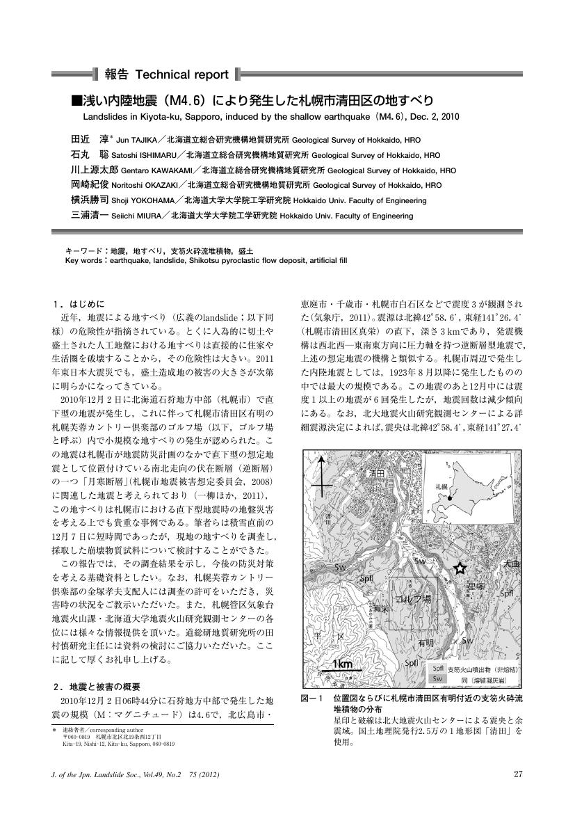
1 0 0 0 浅い内陸地震(M4.6)により発生した札幌市清田区の地すべり
- 著者
- 田近 淳 石丸 聡 川上 源太郎 岡崎 紀俊 横浜 勝司 三浦 清一
- 出版者
- 公益社団法人 日本地すべり学会
- 雑誌
- 日本地すべり学会誌 : 地すべり = Journal of the Japan Landslide Society : landslides (ISSN:13483986)
- 巻号頁・発行日
- vol.49, no.2, pp.75-79, 2012-03-25
- 参考文献数
- 9
- 被引用文献数
- 1
1 0 0 0 OA 2015年に発生した阿寒湖付近の地震(MJMA 5.0)
- 著者
- 一柳 昌義 高橋 浩晃 山口 照寛 岡田 和見 大園 真子 岡崎 紀俊
- 出版者
- 北海道大学大学院理学研究院
- 雑誌
- 北海道大学地球物理学研究報告 (ISSN:04393503)
- 巻号頁・発行日
- vol.79, pp.1-8, 2016-03-19
An M5.0 shallow earthquake occurred on 4 June 2015 in the eastern Hokkaido. In order to evaluate aftershock activity, three temporal seismic stations had been operated in the focal region from 4 June 2015 to 22 August 2015. Hypocenters calculated with a local seismic velocity structure indicated clear southwestern-dipping distribution. This alignment on a plane was consistent with one of nodal plane of mainshock focal mechanism. This earthquake and historical records suggested higher seismic activity in this region.
1 0 0 0 OA 北海道南西部奥尻島で発見された津波堆積物
- 著者
- 加瀬 善洋 仁科 健二 川上 源太郎 林 圭一 髙清水 康博 廣瀬 亘 嵯峨山 積 高橋 良 渡邊 達也 輿水 健一 田近 淳 大津 直 卜部 厚志 岡崎 紀俊 深見 浩司 石丸 聡
- 出版者
- 一般社団法人 日本地質学会
- 雑誌
- 地質学雑誌 (ISSN:00167630)
- 巻号頁・発行日
- vol.122, no.11, pp.587-602, 2016-11-15 (Released:2017-02-20)
- 参考文献数
- 52
- 被引用文献数
- 3 4
北海道南西部奥尻島南端の低地における掘削調査から,泥炭層中に5枚のイベント堆積物を見出した.イベント堆積物の特徴は次の通りである; (1)陸方向および川から離れる方向へ薄層化・細粒化する,(2)級化層理を示す,(3)粒度組成の特徴は河床砂とは異なり,海浜砂に類似する,(4)粒子ファブリックおよび堆積構造から推定される古流向は概ね陸方向を示す,(5)渦鞭毛藻シストおよび底生有孔虫の有機質内膜が産出する,(6)海側前面に標高の高い沿岸砂丘が発達する閉塞した地形において,現海岸線から内陸へ最大450mほど離れた場所まで分布する.以上の地質・地形学的特徴に加え,過去に高潮が調査地域に浸水した記録は認められないことから,イベント堆積物は津波起源である可能性が極めて高い.14C年代測定結果と合わせて考えると,過去3000-4000年の間に1741年および1993年を含めて少なくとも6回の津波が発生しているものと考えられる.
1 0 0 0 IR 北海道駒ヶ岳火口近傍における臨時高感度地震観測--1999年5月20日〜6月1日
- 著者
- 岡崎 紀俊 一柳 昌義 Gordeev Evgenii 笠原 稔
- 出版者
- 北海道大学大学院理学研究科地球惑星科学専攻(地球物理学)
- 雑誌
- 北海道大学地球物理学研究報告 (ISSN:04393503)
- 巻号頁・発行日
- no.64, pp.165-181, 2001-03

