11 0 0 0 高等学校地理科目における土壌教育内容の更新の必要性
- 著者
- 藤井 一至 松浦 陽次郎 菅野 均志 高田 裕介 平舘 俊太郎 田村 憲司 平井 英明 小崎 隆
- 出版者
- 日本ペドロジー学会
- 雑誌
- ペドロジスト (ISSN:00314064)
- 巻号頁・発行日
- vol.63, no.2, pp.73-81, 2019 (Released:2020-12-31)
- 参考文献数
- 23
2022年から実施される学習指導要領の改訂では,地理歴史科の科目が「地理総合」,「地理探求」に変更となり,地図や地理情報システムの活用による国際性,主体的な思考力の養成が求められることとなった。これにあわせて,土壌に関して国内外で蓄積されてきた研究成果を基礎にした,正確な地図および用語を高校生が活用できるように,高校地理の土壌に関わる教育内容の更新が喫緊の課題である。そこで,現行の高校地理(地理B)の教科書にみられる用語および地図の問題点を整理し,教育内容の修正・更新案を提示した。具体的には,(1)チェルノーゼム,プレーリー土,パンパ土,栗色土の統一,(2)単独の土壌分類名と対応しないツンドラ土の削除,(3)「ラテライト」の削除とフェラルソル(ラトソル)への統一,(4)ポドゾル,フェラルソルの分布域の過大評価の修正,(5)テラロッサ,テラローシャを含む「粘土集積土壌」の追加,(6)間帯土壌(成帯内性土壌)として黒ボク土,沖積土の追加である。これによって,世界の土壌の分布と生業や文化との関わり,日本の主要な土壌の地理的分布とその特異性の理解促進に貢献できる。
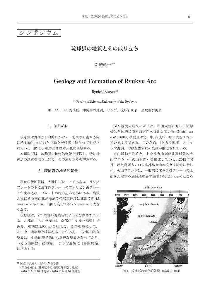
9 0 0 0 OA 琉球弧の地質とその成り立ち
- 著者
- 新城 竜一
- 出版者
- 日本ペドロジー学会
- 雑誌
- ペドロジスト (ISSN:00314064)
- 巻号頁・発行日
- vol.60, no.1, pp.47-54, 2016 (Released:2017-02-23)
- 参考文献数
- 27
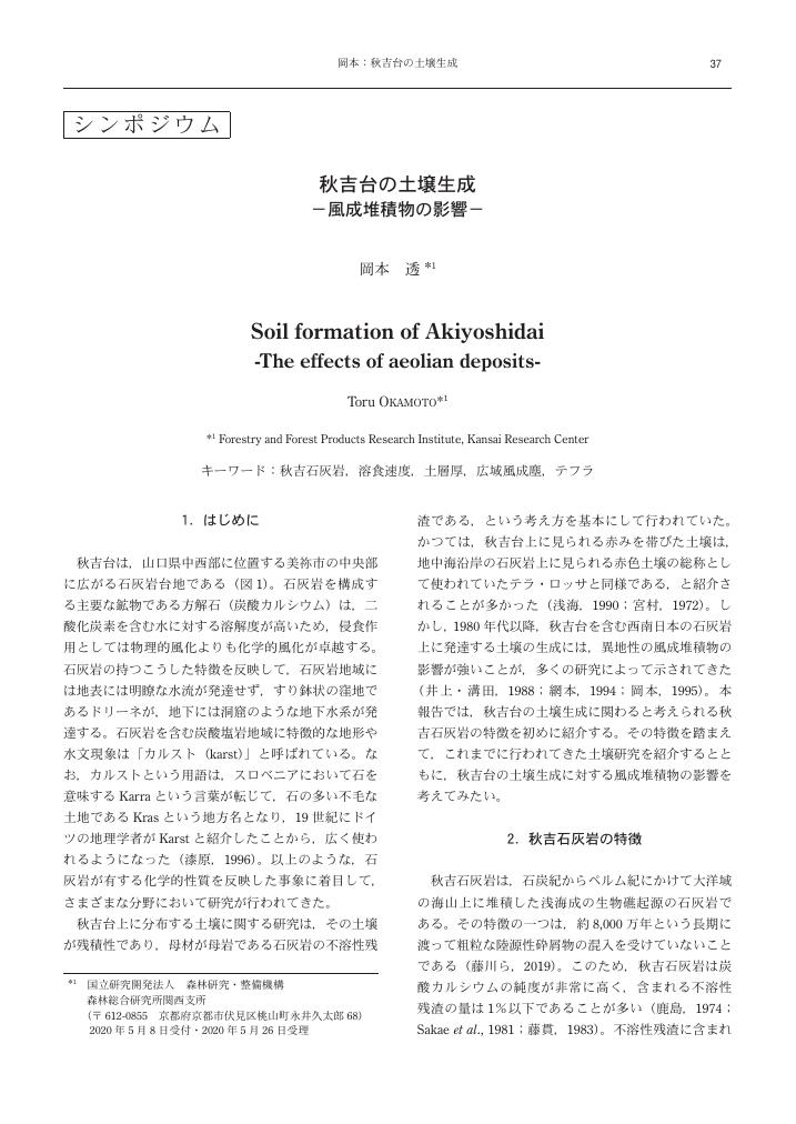
4 0 0 0 OA 秋吉台の土壌生成 -風成堆積物の影響-
- 著者
- 岡本 透
- 出版者
- 日本ペドロジー学会
- 雑誌
- ペドロジスト (ISSN:00314064)
- 巻号頁・発行日
- vol.64, no.1, pp.37-42, 2020 (Released:2021-06-30)
- 参考文献数
- 27
- 著者
- 坂上 寛一
- 出版者
- 日本ペドロジー学会
- 雑誌
- ペドロジスト (ISSN:00314064)
- 巻号頁・発行日
- vol.22, no.1, pp.93-94, 1978-06-30 (Released:2018-06-30)
2 0 0 0 OA "アカホヤ"の語源
- 著者
- 長友 由隆
- 出版者
- 日本ペドロジー学会
- 雑誌
- ペドロジスト (ISSN:00314064)
- 巻号頁・発行日
- vol.36, no.2, pp.75, 1992-12-31 (Released:2018-06-30)
2 0 0 0 シンポジウム 島根県の土壌と農業
- 著者
- 松本 真悟
- 出版者
- ペドロジスト編集部
- 雑誌
- ペドロジスト (ISSN:00314064)
- 巻号頁・発行日
- vol.58, no.2, pp.88-92, 2014-12
島根県は中国山地の北側に位置し,東西の距離は約230kmで,日本海に面する海岸線の長さは1,027kmにおよぶ。中国山地から日本海へと急傾斜する土地は狭長で,全般に平地が少なく,林野面積は526,000haであり,総土地面積の78.4%を占めている。島根県の耕地面積は38,000haで,このうち水田が30,500haを占めており,水田率は80.3%と非常に高い。地力保全基本調査(1959~1977)によれば,水田は7土壌群,22土壌統群,68土壌統に,また樹園地を含む畑地は8土壌群,21土壌統群,58土壌統に区分されている。本稿では,このような土壌特性を示す島根県において,土壌の改良と農業生産の向上について著者らが関わったいくつかの島根県特有の事例について紹介したい。
- 著者
- 菅野 一野 有村 玄洋
- 出版者
- 日本ペドロジー学会
- 雑誌
- ペドロジスト (ISSN:00314064)
- 巻号頁・発行日
- vol.2, no.2, pp.78-80, 1958
2 0 0 0 OA これからの土壌保全のネットワーク
- 著者
- 三輪 睿太郎
- 出版者
- 日本ペドロジー学会
- 雑誌
- ペドロジスト (ISSN:00314064)
- 巻号頁・発行日
- vol.51, no.2, pp.133-136, 2007-12-31
- 被引用文献数
- 1
- 著者
- KATO Taku HIGASHI Teruo KAMIJO Takashi TAMURA Kenji TANI Masayuki 加藤 拓 谷 昌幸
- 出版者
- 日本ペドロジー学会
- 雑誌
- ペドロジスト
- 巻号頁・発行日
- vol.55, no.2, pp.77-81, 2011
http://pedology.ac.affrc.go.jp/BackNumber/index.html
2 0 0 0 OA 火山灰土における有機物の集積過程とC-14年齢(前会長山田忍教授退官記念号)
- 著者
- 和田 光史
- 出版者
- 日本ペドロジー学会
- 雑誌
- ペドロジスト (ISSN:00314064)
- 巻号頁・発行日
- vol.11, no.1, pp.46-58, 1967-06-30
The accumulation of organic matter in volcanic ash soils has been discussed on the basis of a simple mathematical model; dX/dt=A-rX (1), where X is the organic matter in the soil, A the annual addition of plant residue, r the fraction of X decomposed of the soil organic matter per year and t time. By integrating the equation (1) on the assumption of the constancy of A and r, and substituting X by C, the following equation is derived; C=C_m-C_me^<-rt> (2), where C is the carbon % of the soil (corresponding to 10 cm depth of the original ash) and C_m the maximum carbon % of the soil at an equilibrium; dX/dt=0=A-rX. The values of A (=2.1-4.4 ton/ha), r (=0.005-0.0105) and C_m (=20%) are at first estimated from available data on the soils at the supposed equilibrium, and the curves representing the most rapid and slowest accumulation of the organic matter expecting in the volcanic ash soils are depicted in Fig. 1. No suitable datum has been availble to test the feasibility of these accumulation curves except for those in the very early period, which show a reasonable agreement. Then, the value of r has been checked by comparing the average age of the organic matter calculated on the basis of the above accumulation model with that estimated from the measurement of its C-14 specific radioactivity. The average age of the organic matter t^^- at some time t is t^^-=(_0∫^tt(C_m-C_me^<-r>) e^<-rt>・dt)/(_0∫^t(Cm_-C_me^<-r>) e^<-rt>・dt) (3), where (C_m-C_me^<-r>) is the annual increment of the soil organic carbon. By integration, the t^^--t relationship is calculated from the following eaqution ; t^^-=1/r((e^<-rt>(-rt-1)+1)/(-e^<-rt>+1)) (4) The t^^--t curve with r=0.005 (Fig. 2) that corresponds to the slowest accmulation in Fig. 1 shows the maximum average age of the organic matter to be 200 years. The available data of the C-14 age of surface volcanic ash soils, however, indicate much greater average age, and hence much smaller r values such as 0.000125 to 0.0005. This disagreement between the values of r calculated and observed has been solved formally by introducing a factor f, the fraction of A entered into the reservoir of the soil organic matter, into the equation (1). Then, the most probable C-t relationships expecting in the accumlation of the organic matter in the volcanic ash soils are calculated using the equation (2) and delineated in Fig. 3 with hatched lines, where the initial rapid accumulation has been also taken into consideration. The C-t (Fig. 3) and the corresponding t^^--t (Fig. 2) curves thus derived can be used for the dating of the deposition of a buried volcanic ash. As an example, analyses of the data related to the deposition of particular ashes " Imogo" in Kyushu Island have been attempted. The probable time limits for the initiation and termination of the organic matter accumulation (as shown in Fig. 4 as white and black rectangles, respectively) are calculated from the C-14 age of the soil organic matter (vertical arrows) which accumulated in the volcanic ash layers deposited below and above "Imogo" ashes. Comparisons of these time limits have led to conlcude that there are at least two different "Imogo" ashes; the one deposited at 5000〜5250±300 yr. B.P. (lateral arrows) and another deposited not earlier than about 4000 yr. B.P.
1 0 0 0 OA 非アロフェン黒ぼく土における土壌菌核粒子の分布と土壌化学性との関係
- 著者
- 坂上 伸生 渡邊 眞紀子 太田 寛行 藤嶽 暢英
- 出版者
- 日本ペドロジー学会
- 雑誌
- ペドロジスト (ISSN:00314064)
- 巻号頁・発行日
- vol.48, no.1, pp.24-32, 2004-06-30 (Released:2018-06-30)
- 参考文献数
- 17
- 被引用文献数
- 1
Sclerotium grain is the resting body of ectomycorrhizal fungi found in forest soils. A melanic-spherical shape in approximately 1-2mm diameter characterizes the external feature of the grain, and a hollow structure with honeycomb transverse wall appears inside the grain. In our previous studies, we reported a high aluminum concentration inside sclerotium grains and suggested the close relationship between the status of active aluminum and the distribution of these grains in Andosols (Watanabe et al., 2001; 2002). Here we examined the chemical properties focused on active aluminum and carbon in several nonallophanic Andosols under forest vegetation for further discussions on the regulating factor of the distribution of the sclerotium grains. In each studied soil profile, the mean weight of sclerotium grain (mg grain^<-1>) had a tendency to increase with the content of exchangeable aluminum, content of total organic carbon and nitrogen, carbon content of humic acid extracted from soils. The ratio of Alp to total organic C(Al_p/T-C) showed a strong negative correlation between the mean weight sclerotium grains regardless of profiles. The bonding ratio of carbon and aluminum in soils was assumed to be one of the factor influencing the development of sclerotium grains.
1 0 0 0 OA クラカタウ諸島の火山性土壌について(<シンポジウム特集>熱帯~暖温帯の黒色及び赤黄色の土壌,1.アンドソルをめぐって-ICOMANDの活動をふまえて-,第24回ペドロジスト・シンポジウム)
- 著者
- 品川 昭夫 宮内 信文 東 照雄 Muhamad Rahman DJUWANSAH Achmad SULE
- 出版者
- 日本ペドロジー学会
- 雑誌
- ペドロジスト (ISSN:00314064)
- 巻号頁・発行日
- vol.29, no.2, pp.126-135, 1985-12-31 (Released:2018-06-30)
- 被引用文献数
- 1
1 0 0 0 OA 理想のフィールド・ペドロジスト
- 著者
- 三浦 英樹
- 出版者
- 日本ペドロジー学会
- 雑誌
- ペドロジスト (ISSN:00314064)
- 巻号頁・発行日
- vol.60, no.1, pp.1-3, 2016 (Released:2017-02-23)
- 被引用文献数
- 1
1 0 0 0 OA 土色にまつわる分類名称の課題
- 著者
- 若林 正吉
- 出版者
- 日本ペドロジー学会
- 雑誌
- ペドロジスト (ISSN:00314064)
- 巻号頁・発行日
- vol.63, no.2, pp.59-60, 2019 (Released:2020-12-31)
1 0 0 0 カーチス・フレッチャー・マーブット-ペドロジスト列伝IV-
- 出版者
- 日本ペドロジー学会
- 雑誌
- ペドロジスト (ISSN:00314064)
- 巻号頁・発行日
- vol.7, no.2, 1963
1 0 0 0 OA 水田土壌中の灰白色炭酸鉄結核について
- 著者
- 岩佐 安
- 出版者
- 日本ペドロジー学会
- 雑誌
- ペドロジスト (ISSN:00314064)
- 巻号頁・発行日
- vol.3, no.2, pp.53-58, 1959-12-30
A grayish white concretion was taken from the G horizon of a paddy soil developed on the Abe river plain. It was examined by physical and chemical analyses, D. T. A. and X-ray diffraction. From the results obtained, it was concluded that the sample was dominated by siderite (FeCO_3). The sample was crushed and divided into 2 fractions. One fraction was added in water and kept in the constant temperature (28℃), and another kept in room temperature under dry condition. After 35 days, each fraction was again examined by X. R. D. and D. T. A.. It was seen that much more goethite (Fe_2O_3・H_2O) was formed from siderite under the wet condition, but little under the dry condition.
1 0 0 0 OA 統一的土壌分類への道筋
- 著者
- 三土 正則
- 出版者
- 日本ペドロジー学会
- 雑誌
- ペドロジスト (ISSN:00314064)
- 巻号頁・発行日
- vol.35, no.1, pp.1, 1991-06-30 (Released:2018-06-30)
- 被引用文献数
- 1
1 0 0 0 松井さんの土の見方に魅せられて(<追悼特集>松井先生の思い出)
- 著者
- 菊地 晃二 浜崎 忠雄
- 出版者
- 日本ペドロジー学会
- 雑誌
- ペドロジスト (ISSN:00314064)
- 巻号頁・発行日
- vol.53, no.2, pp.107-108, 2009
1 0 0 0 OA 浅間山噴火(1783年)に伴う泥流により埋没した畑遺構土壌の理化学的特徴
- 著者
- 須永 薫子 坂上 寛一 関 俊明
- 出版者
- 日本ペドロジー学会
- 雑誌
- ペドロジスト (ISSN:00314064)
- 巻号頁・発行日
- vol.47, no.1, pp.14-28, 2003-06-30 (Released:2018-06-30)
- 参考文献数
- 33
群馬県下の浅間山(1783年)噴火に伴う泥流により埋没した畑遺構土壌の理化学性を検討するため,泥流直下の江戸時代表層土から当時の畑跡と対照地の土壌を採取し,比較検討した結果,下記のことが明らかとなった。1)本報告で用いた久々戸,下原は文献史料や近傍の他の遺跡の研究から埋没の経緯が明らかな遺跡であった。泥流は短時間で大量に堆積し,泥流による江戸時代表層土へのかく乱は少なく,よく保存され,江戸時代表層土に畝の形状を明瞭に確認することができた。畝の有無を基準に畑跡と対照地を容易に区別することができた。2)泥流層の理化学性は,久々戸,下原のいずれでも類似しており,変動係数が小さく,ほぼ均質の性質を示し,一斉に江戸時代表層土を埋没させたことがわかった。3)江戸時代の畑跡土壌は対照土壌に比べ,久々戸,下原ともに固相率,全炭素量,全窒素量,易分解性有機物量は高く,可給態リン酸量は低かった。現代の表層土においても同様の結果が得られた。畑として利用することによって生じる共通した土壌の理化学性と考えられた。4)江戸時代の畑跡土壌の交換性カリウム量は畝の形状の変化に対応し変化した。これは,カリウムを多く含むなんらかの肥料が施用されたことを示唆している。5)江戸時代表層土の化学性は,全分析項目で現代の表層土と比べ,低い傾向を示した。また,江戸時代表層土の全炭素量,全窒素量,リン酸吸収係数およびCECは,母材の影響により変化した。6)易分解性有機物量/可給態リン酸量の比(E.D.O/A.P)は畑跡土壌で対照土壌に比べ1/2以下であった。この比は畑として利用することにより低下すると考えられ,埋没した江戸時代の畑跡にとどまらず過去に畑であったことを化学的に識別する有効な指標として利用することができる。
1 0 0 0 OA 「土」と「土壌」は同じか? -問題提起-
- 著者
- 永塚 鎭男
- 出版者
- 日本ペドロジー学会
- 雑誌
- ペドロジスト (ISSN:00314064)
- 巻号頁・発行日
- vol.56, no.1, pp.28-33, 2012 (Released:2019-04-02)
- 参考文献数
- 11
わが国における「土」および「土壌」という用語の使用状況を歴史的に検討した結果,「土」というのは「地表を覆う細かく砕けやすい堆積物」を単なる物質としてとらえた表現であり,「土壌物質」に相当することを示した。したがって,「土壌」という語を自然体としての土壌(土壌体)に限って使用するのが適切であると考えられる。一般市民に土壌の大切さを理解してもらうためには,ペドロジスト自身が,「土壌」と「土」の違いを,上記のように意識的に区別して使用することが重要であり,そのように積極的に行動することを提案した。


