1 0 0 0 OA 台湾泥火山の地質構造と地化学特性
- 著者
- 浜田 好弘 田中 和広 宮田 雄一郎
- 出版者
- 公益社団法人 東京地学協会
- 雑誌
- 地学雑誌 (ISSN:0022135X)
- 巻号頁・発行日
- vol.118, no.3, pp.408-423, 2009-06-25 (Released:2010-03-26)
- 参考文献数
- 38
- 被引用文献数
- 9 8
The geology and geochemistry of mud volcanoes in Taiwan was investigated to elucidate the relationship between their distribution and geological structure and the mechanism of ascending fluid migration from deep underground regions caused by abnormal pore water pressure. A detailed geological survey was carried out to describe the geological structure and the stratigraphy of mud volcanoes in the Pliocene Gutingkeng Formation in the Hsiaokunshui area. Groups of several to tens of mud volcanoes are distributed along the anticline axis within an area of 400 m in diameter. Mud volcanoes are classified into three types on the basis of differences in their morphological features (pudding type, crater type and pool type) corresponding to three types of erupted groundwater having different viscosities. As a result of geochemical studies on groundwater that erupted from mud volcanoes, it is shown that the geochemistry of groundwater that erupted from mud volcanoes distributed along the anticline, such as the Hsiaokunshui mud volcanoes, is characterized by lower δ18O ratios and high concentrations of soluble ions compared to those distributed along the Chishan Fault. Also, it is concluded that pressurized groundwater diluted by water produced during the dehydration of clay minerals ascended through the Chishan Fault and along the Hsiaokunshui anticline. On the other hand, on the basis of high δ18O ratios, it is suggested that the groundwater of mud volcanoes along the Chishan Fault was quickly expelled from underground regions deeper than those along the Hsiaokunshui anticline. Also, the groundwater of mud volcanoes along the Hsiaokunshui anticline ascended through a variety of paths from the mud chamber to the ground surface, and consequently various types of mud volcanoes were formed on the ground surface.
- 著者
- 二上 政夫 宮田 雄一郎
- 出版者
- 一般社団法人 日本地質学会
- 雑誌
- 地質学雑誌 (ISSN:00167630)
- 巻号頁・発行日
- vol.89, no.1, pp.31-40_2, 1983-01-15 (Released:2008-04-11)
- 参考文献数
- 36
1 0 0 0 OA 用語解説「皿状構造」
- 著者
- 辻 隆司 宮田 雄一郎
- 出版者
- The Sedimentological Society of Japan
- 雑誌
- 堆積学研究 (ISSN:1342310X)
- 巻号頁・発行日
- vol.45, no.45, pp.59-63, 1997-06-25 (Released:2010-05-27)
- 参考文献数
- 9
1 0 0 0 777. 北海道産白亜紀オウムガイ類-V
- 著者
- 松本 達郎 宮内 敏哉 蟹江 康光 宮田 雄一郎 植用 芳郎
- 出版者
- 日本古生物学会
- 雑誌
- 日本古生物学會報告・紀事 新編 (ISSN:00310204)
- 巻号頁・発行日
- vol.1984, no.134, pp.335-346_1, 1984
- 被引用文献数
- 1
その5-7を含む, その5.下部白亜系産同類。A.宗谷と大夕張産の1種 : Cymatoceras sp. aff. C. virgatum (Spengler).インドのアルビアン産模式標本に類似するが, 殻側面がそれ程膨れずB/Hが1に近く, 肋は2分岐を何回か示すが3分岐は認められない。大夕張のはアルビアン;宗谷のは層位未定。B.浦河地域産の1種 : Cymatoceras sp. cf. C. sakalavum Collignon.浦河北々西17kmの鳧舞川支流の1地点, 中部エゾのMla砂岩産。二次変形しているがマダガスカル島アルビアン産の標記種に類似。C.礼文島ネオコミアン産1種 : Cymatoceras sp. aff. C. mikado (Krenkel).タンザニアのネオコミアン産のに類似するが, 螺環断面が準梯形でへそも広い。地蔵岩近傍の礼文層群最下部層産。その6.サントニアン産の追加1種 : Cymatoceras sharpei (Schluter).ドイツのセノマニアン産原標本よりはむしろオーストリアGosau層群サントニアンから最近報告のものによく似る。幾春別川上流サントニアンより高橋武美氏採集。その7.北海道産白亜紀オウムガイ類成果の要約。(1)記載した15種を表示, 産出層の時代を併記(p.341). (2) Kummeloceras属を設立し, 系統分類について新知見を提示(第4図の系統樹参照). (3)各階ごとに異なる種が産しており, 中には化石帯構成種のメンバーたり得るものもある。海外類似種との対比のできるものもある。(4)古生物地理, (5)古環境についても, 若干のまとめを試みた。
1 0 0 0 対州層群の形成年代と堆積環境
- 著者
- 二宮 祟 市原 季彦 谷口 翔 下山 正一 宮田 雄一郎 ダニエル ダンクレイ 松田 博貴 山中 寿朗 青木 隆弘 西田 民雄
- 出版者
- 一般社団法人 日本地質学会
- 雑誌
- 日本地質学会学術大会講演要旨 (ISSN:13483935)
- 巻号頁・発行日
- vol.2009, pp.132, 2009
- 著者
- 徳橋 秀一 クリストファーM. アギンギー 宮田 雄一郎 石原 与四郎 三田 勲
- 出版者
- 石油技術協会
- 雑誌
- 石油技術協会誌 (ISSN:03709868)
- 巻号頁・発行日
- vol.66, no.1, pp.81-94, 2001 (Released:2008-03-27)
- 参考文献数
- 44
- 被引用文献数
- 2 1
The controlling factors and principles which govern the spatial and chronological distribution of turbidite sandstones have been investigated based on the results of sedimentological, petrographical, and mathematical analyses on the Neogene and Quaternary turbidite sandstones in the forearc and backarc basins, central Japan. Main conclusions are as follows:1) The sedimentological research revealed that the three-dimensional forms of individual turbidite sandstone beds, which are part of a depositional lobe of submarine fan system and regionally correlated bed by bed by using many useful tuff key beds, are similar to each other. The similarity continues vertically within the interval of a single depositional lobe or of a certain stratigraphic unit. Their thickness and distribution area reflect the magnitude of turbidity currents, while their form greatly depends on the grain size distribution of the sediments.2) The petrographical research proved that the heavy mineral composition can be used as a good indicator to recognize turbidite sandstone bodies which share a single source area, and are useful to check the original relationship of turbidite sandstone bodies isolated each other.3) The mathematical research led to the conclusion that the development of turbidite sandstones is controlled by the global changes such as the eustaic sea level changes, because the periodicity in an order same as the Milankovitch's cycles was recognized in the vertical change of number and total thickness of turbidite sandstone beds within an interval delineated by a certain accumulated thickness of hemipelagite in several turbidite successions.
1 0 0 0 OA 淡水成デルタと海成デルタの堆積作用
- 著者
- 鍋谷 淳 宮田 雄一郎 山村 恒夫 岩田 尊夫 小幡 雅之
- 出版者
- 石油技術協会
- 雑誌
- 石油技術協会誌 (ISSN:03709868)
- 巻号頁・発行日
- vol.55, no.2, pp.113-120, 1990 (Released:2008-03-27)
- 参考文献数
- 15
Rivers characterized by suspended load and bed load tend to build fine-grained deltas and coarse-grained deltas, respectively. Gilbert-type deltas consisting of topset, foreset, and bottomset beds are recognized in marine environments as well as in lakes. Coarse-grained deltas tend to be Gilbert-type deltas. However, fine-grained deltas built in deep-water rivermouths and in wave-dominated rivermouths are mostly Gilbert-type deltas.Bird foot, lobate, cuspate, and estuarine deltas are recognized in marine environments. In contrast, estuarine deltas do not occur in lakes, since lakes are less subjected to tidal influences than seas.
1 0 0 0 OA 日南海岸沿いの深海堆積相と重力流堆積物
- 著者
- 石原 与四郎 髙清水 康博 松本 弾 宮田 雄一郎
- 出版者
- 一般社団法人 日本地質学会
- 雑誌
- 地質学雑誌 (ISSN:00167630)
- 巻号頁・発行日
- vol.120, no.Supplement, pp.S41-S62, 2014-08-31 (Released:2014-12-26)
- 参考文献数
- 40
- 被引用文献数
- 2 2
宮崎県の日南海岸沿いには,古第三系~新第三系の深海相がよく露出する.このうち日南市の猪崎には,古第三系日南層群がオリストリスとして見られる.その内部はチャネル・レビーシステムのタービダイトサクセッションから構成されるが,ソールマークや生痕化石が顕著に観察できるとともに,様々な液状化・流動化構造がよく発達していることで知られている.日南層群を不整合で覆う宮崎層群は,前孤海盆充填堆積物であり,粗粒な“宮崎相”と砂岩泥岩互層からなる“青島相”からなる.“宮崎相”は河川~浅海および,狭い陸棚をもつ斜面上に形成されたファンデルタシステムで,相対的海水準の変動と対応した堆積相の分布を示す.これらには石灰岩や波浪を特徴付ける堆積相,さらに重力流堆積物が顕著である.一方,“青島相”は海岸沿いによく露出し,全体的に単調な砂岩・泥岩互層からなる“タービダイト”サクセッションをなす.これらの“タービダイト”は,通常とは異なる堆積構造をもち,その重なりは通常のタービダイトサクセッションとは違う層厚分布を示す.そして一部には津波堆積物と考えられる厚層理砂岩層も挟在する.●本巡検では,主に日南海岸沿いに分布するこれらの深海相・タービダイトサクセッションをめぐり,様々な重力流堆積物やそれらが構成する地層を見学する.
1 0 0 0 房総半島安房層群上部のタービダイトシークエンスの時系列解析
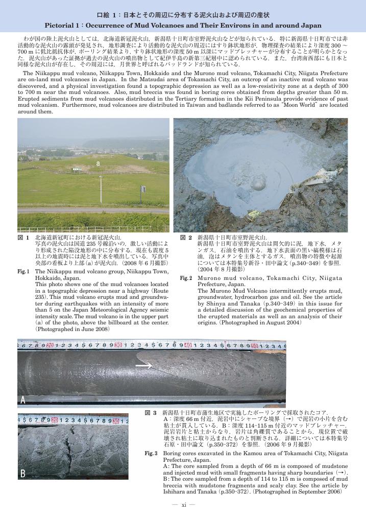
1 0 0 0 OA 口絵1:日本とその周辺に分布する泥火山および周辺の産状
1 0 0 0 マッドクラックのパターン形成実験
1 0 0 0 OA 2009年7月中国・九州北部の豪雨による水・土砂災害と防災対策に関する研究
- 著者
- 羽田野 袈裟義 安福 規之 兵動 正幸 橋本 晴行 久保田 哲也 福岡 浩 里深 好文 山本 晴彦 高橋 和雄 宮田 雄一郎 鈴木 素之 牛山 素行 田村 圭子 後藤 健介 藤田 正治 牧 紀男 朝位 孝二 善 功企 守田 治 滝本 浩一 三浦 房紀 種浦 圭輔
- 出版者
- 山口大学
- 雑誌
- 特別研究促進費
- 巻号頁・発行日
- 2009
(1)災害概況:2009年7月の豪雨により防府地域と福岡県北半部の全域で土砂災害が多発し合計で27名が亡くなった.(2)土砂災害の実態:防府の土砂災害は,土石流中の巨礫堆積後の土砂流による埋没である.土質調査からマサ土地域での崩壊発生と間隙水圧の関係が示唆された.土石流の流動解析で石原地区の土砂流出量を評価し,砂防施設の有効性を評価した.(3)情報伝達と警戒避難体制の状況:防災・避難情報の収集・伝達や警戒避難体制の整備状況や土砂災害警戒区域の指定に伴う警戒避難体制の整備状況と問題点を明らかにした.


