3 0 0 0 OA 赤石山脈南部,大谷崩から山伏にかけての山体重力変形地形
- 著者
- 目代 邦康 千木良 雅弘
- 出版者
- The Association of Japanese Geographers
- 雑誌
- 地理学評論 (ISSN:13479555)
- 巻号頁・発行日
- vol.77, no.2, pp.55-76, 2004-02-01 (Released:2008-12-25)
- 参考文献数
- 82
- 被引用文献数
- 9 10
赤石山脈南部の大谷崩から山伏にかけて,幅の広い緩斜面を頂部に持つ山稜が分布する.これらの山稜最上部には比高10m以上の凹地(山上凹地)があり,その下方には比高数m程度の山向きの小さな崖(山向き小崖)が発達する.この地域には瀬戸川帯のスレートが分布し,その壁開の走向は上記の凹地と小崖の伸びの方向と大略平行である.これらの凹地・小崖地形は,山体を構成する岩盤が斜面下方に倒れかかった結果形成された重力変形地形であると推定できる.崖頂部の丸みの程度,凹地内堆積物の層相とテフラが示す変形時期,山上凹地・山向き小崖の配列と分岐パターンは,山体の変形が,山体上部から下部へと進行し,かつ地層の走向方向から等高線に沿う方向へと進行したことを示している.稜線付近にある上位の山向き小崖は,少なくとも2万年前には存在しており,下位の山向き小崖は約1万年前に形成されたと考えられた.
2 0 0 0 OA 高レベル放射性廃棄物の地層処分について
- 著者
- 千木良 雅弘
- 出版者
- 公益財団法人 日本学術協力財団
- 雑誌
- 学術の動向 (ISSN:13423363)
- 巻号頁・発行日
- vol.18, no.6, pp.6_46-6_49, 2013-06-01 (Released:2013-10-01)
2 0 0 0 OA 愛知県旧小原村の風化花崗岩類における崩壊発生密度の岩相間での比較
- 著者
- 戸邉 勇人 千木良 雅弘 土志田 正二
- 出版者
- 一般社団法人日本応用地質学会
- 雑誌
- 応用地質 (ISSN:02867737)
- 巻号頁・発行日
- vol.48, no.2, pp.66-79, 2007-06-10
- 参考文献数
- 47
- 被引用文献数
- 3 6
1972年,愛知県小原村では豪雨により花崗岩類の崩壊が多数発生した.われわれはその被災地で崩壊の分布・密度に対する岩相と降雨量の影響を数値的に検討した.5時間で約200mmの降雨を受けた同一地域であるにもかかわらず,花崗岩地域の崩壊密度は293/km^2であり花崗閃緑岩の値(13/km^2)を一桁以上上回った.また,花崗岩地域では降雨量増大とともに崩壊密度の増大が認められたが,花崗閃緑岩地域では認められなかった.航空レーザー測量を約3km^2の範囲で行い,空中写真と対比し,この災害時だけでなくそれ以前に発生した崩壊も抽出した結果,崩壊密度の差がこの災害以前から存在し続けていたことがわかった.これらの差は,岩相間で風化帯構造が異なることによると推定される.花崗岩地域ではD_H〜D_M級の硬質なマサがもっとも広く分布し,それらは斜面表層部に明瞭な緩み前線を伴っていたため,崩壊しやすかったと推定される.また,一部の花崗岩にはマイクロシーティングが発達し,崩壊発生を助長していた.一方,花崗閃緑岩地域ではD_L級のマサが広く分布し,それは強風化しているが,明瞭な緩み前線を伴っていなかったため,崩壊数が少なかったと推定される.
- 著者
- 中田 英二 千木良 雅弘
- 出版者
- 公益社団法人 東京地学協会
- 雑誌
- 地学雑誌 (ISSN:0022135X)
- 巻号頁・発行日
- vol.118, no.3, pp.511-532, 2009-06-25 (Released:2010-03-26)
- 参考文献数
- 40
- 被引用文献数
- 10 9
Understanding erosion processes is important to prevent natural disasters such as slope failure and bedrock erosion in immature sedimentary rocks. Pliocene–Pleistocene illite-rich, non-smectite mudstone of the Gutingkeng Formation is distributed over 250 km2 in southern Taiwan, forming badlands (locally called moon-world) with mud volcanoes nearby. These volcanoes erupt saline water and natural gas, and producing a Na+, Ca2+, Cl-, and SO42- rich unsaturated Popcorn crust, which covers the mudstone slope surfaces in the moon-world area. In the crust porewater, ion strength reaches about 10 mol/L; zeta potential on particle surfaces shows a highly positive voltage. Repulsion occurs between particles under this high voltage in the crust, which is rapidly slaked to form mud by heavy precipitation. The zone that is rapidly slaked by precipitation reaches 10-20 cm beneath the crust surface. Ion strength of porewater of fresh mudstone is 0.5 mol/L approaches 0 mV (range 0.2-0.5 mol/L, pH 4-6). The surface charge of particles decreases with the infiltration of precipitation into the crust and fresh rock, with a minus surface charge occurring with increased rain infiltration. This leads to many cracks forming on the surface of mudstone, which is different from the mechanism of rapid slaking. Evaporation from the 10-20 cm-thick zone between the crust and the underlying fresh mudstone would stop if water was not supplied from depth, which is supported by in-situ measurements of water evaporation in the field. These mudstones erode readily under high precipitation because of the repulsion caused by the high ion strength of porewater. High-salinity porewater including mudstone is distributed near the active mud volcanoes where saline water rises and there is a rapid uplift rate. Rapid slaking occurred with some elements in the concentrated crust and near the surface drying zone.
1 0 0 0 OA 深層崩壊の場所の予測と今後の研究展開について
- 著者
- 千木良 雅弘
- 出版者
- 一般社団法人 日本応用地質学会
- 雑誌
- 応用地質 (ISSN:02867737)
- 巻号頁・発行日
- vol.56, no.5, pp.200-209, 2015-12-10 (Released:2016-01-23)
- 参考文献数
- 31
- 被引用文献数
- 8 6
深層崩壊は,急激な動きと長距離移動を伴い,甚大な災害を引き起こすため,その災害軽減には,場所を予測することが第一に必要である.本論では,深層崩壊の実績に基づいて,発生場所の地質・地形的特徴,および発生危険度についてとりまとめ,最後に今後の研究について展望した.降雨による深層崩壊は,大抵の場合それに先行して重力斜面変形が生じていることから,重力斜面変形のタイプを分類し,これに斜面上部の小崖の有無,斜面下部の崩壊の有無などの地形的特徴を加味して発生危険度を4段階に区分した.地震による深層崩壊には,発生前の斜面不安定化過程がいくつか認められる.1つ目は化学的風化,2つ目は重力斜面変形,3つ目は事前に地すべりが対岸に衝突し,その後下部を侵食などによって切断され,不安定化している場合,4つ目は地震時に水が地下から噴出して発生する地すべりである.深層崩壊に関連して,今後次のような研究の展開が期待される.重力斜面変形の地震時不安定化,ハロイサイトに富む土の動的性質,さらに,粘土や岩石のせん断強度の速度依存性,降雨の高解像度計測とリンクした斜面内部の水の挙動と斜面の不安定化の解明である.
1 0 0 0 OA 結晶片岩の岩盤クリープ(その1) : 関東山地三波川帯の地質構造と地すべり地形との関連
- 著者
- 千木良 雅弘
- 出版者
- 一般社団法人日本応用地質学会
- 雑誌
- 応用地質 (ISSN:02867737)
- 巻号頁・発行日
- vol.25, no.4, pp.182-194, 1984-12-30
- 被引用文献数
- 10 9
Geological and geomorphological invesigation was performed in the Kanto mountainous land to study the relationship between geology and landslide topographies in the Sambagawa terrain where crystalline schist is distributed. Landslide topographies were found to be abundant in pelitic and basic schist ranges and scarce in siliceous schist, psammitic schist, and massive basic rock ranges. It was elucidated that the landslide topographies have the size and the moving direction, both are controlled by the attitude of the basement rocks. The landslide topographies that show the movement about parallel with the dip direction of the basement rocks exceed the other landslide topographies in their number and in their size.
1 0 0 0 OA 「平成20年岩手・宮城内陸地震」災害第一次現地調査報告
- 著者
- 日本応用地質学会平成20年岩手・宮城内陸地震調査団 橋本 修一 千木良 雅弘 中筋 章人 日外 勝仁 亀谷 裕志 野崎 保 森 一司 高見 智之 菖蒲 幸男 小林 俊樹 山本 佑介
- 出版者
- 一般社団法人日本応用地質学会
- 雑誌
- 応用地質 (ISSN:02867737)
- 巻号頁・発行日
- vol.50, no.2, pp.98-108, 2009-06-10
- 参考文献数
- 11
- 被引用文献数
- 6 5
平成20年6月14日朝,岩手県内陸南部を震源としてM7.2の地震が発生した.震源域の山地では,地中で1G超の加速度,地表で2mを超える隆起など大きな地盤変動が観測され,巨大な斜面崩壊や多くの河道閉塞が発生するなど,大小さまざまな規模の地盤災害が多発した.これらの地盤災害を理解するには,地質,地質構造および岩盤特性を正しく把握する必要があるものと考えられた.日本応用地質学会は災害実態を把握するために災害調査団を組織し,9月中旬に第一次現地調査を行い,その概要を平成20年度研究発表会(10月31日横浜)および学会誌(Vol.49,No.6)で速報し,その内容は同学会ホームページに公開している.本報告は,上記現地調査結果を中心にして,調査地区の特徴的な斜面災害状況を記載し,その発生の過程・メカニズムについて現段階までの知見を加えて考察したものである.
- 著者
- 宮崎 裕子 千木良 雅弘 黒川 潮
- 出版者
- 日本地形学連合
- 雑誌
- 地形 = Transactions, Japanese Geomorphological Union (ISSN:03891755)
- 巻号頁・発行日
- vol.26, no.3, pp.205-224, 2005-07-25
- 参考文献数
- 36
- 被引用文献数
- 1
The Niijima and Kozushima earthquake struck Kozushima Island to the south of Tokyo on 1 July 2000, with an intensity of 6-low on the Japanese Meterological Agency scale. The earthquake was followed by heavy rain (cumulative storm precipitation 291mm in 24 hour and maximum hourly precipitation 52mm) on July 7th to 8th and another earthquake occurred on July 9th. These cumulative events triggered many landslides, which we identified on air photographs taken before, during, and after the events, and then mapped on GIS-based topographic and geologic maps to assess the cumulative effects of consecutive earthquake and rainfall on slope failures on a rhyolitic volcano. The successive July 1st earthquake, rainfall, and smaller July 9th earthquake triggered 618, 123, and 102 slope failures, respectively, on rhyolitic lava and pyroclastics that dominate the island. Most of the failures occurred on slopes steeper than 30 degrees near the "erosion front". On jointed rhyolite lava slopes, many earthquake-initiated slope failures occurred because of the high inertial energy within the lava mass during the earthquake. Conversely, few landslides were triggered by rainfall because of the high permeability of the lava. Areas of coarse pyroclastics and crumble breccia suffered from many landslides during the first earthquake but not during the subsequent rainstorm, probably due to the low cohesion and large permeability of these materials. Alternatively, silt or clay-rich pyroclastics experienced more landslides during rainfall compared to the earthquake because of the greater cohesion and lower permeability of these materials. However, rainfall on July 7th to 8th alone appears not to be of sufficient intensity to trigger widespread landslide; previous rainfall events that initiated widespread slope failures on the Kozushima Island had maximum 1-hour intensities >100mm. The earthquake on July 1st could have loosened the surface material, which failed during the subsequent moderate rainfall.
1 0 0 0 OA 1923年関東地震による震生湖地すべりの地質構造とその意義
- 著者
- 千木良 雅弘 笠間 友博 鈴木 毅彦 古木 宏和
- 出版者
- 京都大学防災研究所
- 雑誌
- 京都大学防災研究所年報. B = Disaster Prevention Research Institute Annuals. B (ISSN:0386412X)
- 巻号頁・発行日
- vol.60, no.B, pp.417-430, 2017-09
1923 Kanto earthquake induced numerous numbers of landslides in the western part of Kanagawa Prefecture. In particular, a landslide dam made in Hadano still remains and its lake is known as a quake lake. However, the geological structure of the landslide was not clarified. We made geological and geomorphological investigations for this landslide, using drilling and airborne LiDAR, then found that this landslide had its sliding surface along Tokyo Pumice in the depth of about 17 m and the overlying volcanic soil and pyroclastic flow deposits slid. Tokyo Pumice erupted from the Hakone volcano 66 thousand years ago and is widely distributed in Kanagawa and Tokyo, suggesting that potential earthquake-induced landslides must be considered.
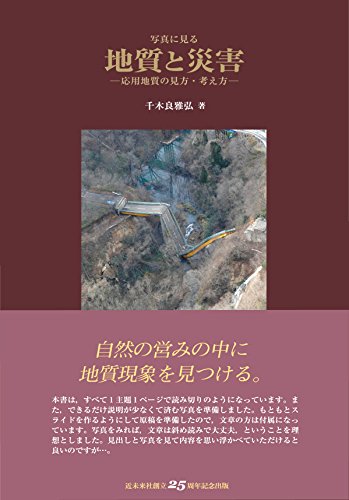
1 0 0 0 写真に見る地質と災害 : 応用地質の見方・考え方
1 0 0 0 42.1949年今市地震による降下火砕物の崩壊の地質的特徴
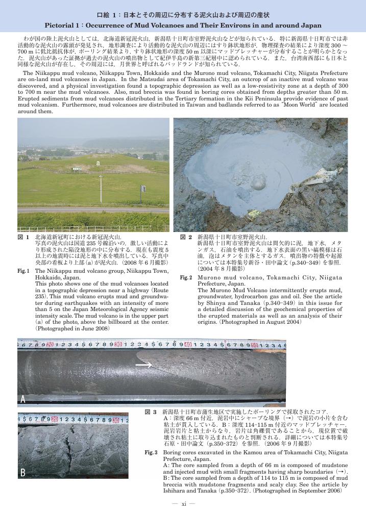
1 0 0 0 北海道南部の泥火山の構造的特徴と活動履歴
1 0 0 0 OA 口絵1:日本とその周辺に分布する泥火山および周辺の産状
1 0 0 0 OA 平成28年熊本地震により発生した軽石層および火山灰土層をすべり面としたテフラ斜面の崩壊
- 著者
- 佐藤 達樹 千木良 雅弘 松四 雄騎
- 出版者
- 日本地球惑星科学連合
- 雑誌
- JpGU-AGU Joint Meeting 2017
- 巻号頁・発行日
- 2017-03-10
2016年4月16日に熊本県熊本地方を震源とする地震(Mw 7.0)が発生し,最大震度7を観測した.震度6強の強い揺れに見舞われた阿蘇カルデラ西部地域では,多くの斜面崩壊が発生した.テフラからなる斜面で発生した斜面崩壊は,緩傾斜斜面で発生し,また,長距離流動した.さらに,これらの崩壊のすべり面の形成された層準にはいくつかの種類があり,調査を行った崩壊地においては,風化した軽石層にすべり面を形成したもの(軽石の崩壊)が最も多く確認され,黒味を帯びた火山灰土層にすべり面を形成したもの(火山灰土の崩壊)が次いで多く,風化した火山灰層やスコリア層にすべり面を形成したものも確認された.そこで,本研究では軽石層および火山灰土層にそれぞれすべり面を形成した崩壊に着目し,これらの崩壊メカニズムを明らかにするために崩壊地の地形・地質的特徴,各層の鉱物組成および物性を検討した. 調査地域の基盤は玄武岩から流紋岩までさまざまな組成をもつ溶岩流や火砕岩から構成され(小野・渡辺,1985),テフラに厚く覆われている.渡辺,高田(1990)によると火山灰土(Volcanic soil)は色調によって分類可能であり,本研究では黒色を呈する黒ボク(Bl),黄褐色を呈する赤ボク(Br),そして,両火山灰土の中間の色調を示す暗褐色火山灰土(Blackish Brown Volcanic soil, BlBr)の3つに分類した.また,調査地域で最も広く分布する軽石は草千里ヶ浜軽石(Kpfa)と呼ばれ,約30000年前に草千里ヶ浜火口から噴出した(宮縁ほか,2003). 軽石層または火山灰土層にすべり面をもつテフラ斜面の崩壊には,共通してすべり面付近にハロイサイトが存在した.軽石の崩壊において最も多くすべり面が形成された軽石層は,草千里ヶ浜軽石(Kpfa)層であり,そのすべり面は風化により粘土化した層に形成された.火山灰土の崩壊においてはBlBr層に最も多くすべり面が形成され,崩壊地内にすべり面の露出する箇所には乾燥亀裂が発達しており,高含水の粘土層がすべり面となったことが分かる.さらに,火山灰土にすべり面を持つ崩壊地にはKpfaをはじめとする明瞭な軽石層が存在しなかったことから現段階では,Kpfa層がテフラ斜面の崩壊において最もすべり面形成層となりやすく,Kpfa層がない場合にBlBr層にすべり面が形成された可能性が考えられる.Kpfa層がない理由の可能性としては,もともと堆積しなかったか,堆積の後に地すべりによって取り去られたことが考えられる.堆積しなかったとすると,その理由としては斜面が急すぎたこと,あるいは軽石の給源からの供給が少なかったことが考えられる.
1 0 0 0 OA On the fluidized landsliding phenomena on gentle slopes triggered by the 2016 Kumamoto Earthquake
- 著者
- 王 功輝 土井 一生 釜井 俊孝 後藤 聡 千木良 雅弘
- 出版者
- 日本地球惑星科学連合
- 雑誌
- JpGU-AGU Joint Meeting 2017
- 巻号頁・発行日
- 2017-03-10
During the 2016 Kumamoto earthquake, numerous landslides had been triggered in Minamiaso Village. Most of the landslides originated on steep slopes, whereas some of them occurring on gentle slopes were fluidized and the displaced debris travelled long travel distance, resulting in causalities and severe damage to many houses on the downslope. In this study, we examined the geological features of these fluidized landslides occurring on gentle slopes, and performed both in-situ direct shear tests and dynamic ring shear tests on the soils taken from the sliding surface. During the tests, the samples were prepared at different initial water contents, and dynamic tests were performed by applying cyclic loadings with regular frequency and amplitude of shear stress, and also by coseismic loading referred from seismic motion recorded in a seismic station nearby. Based on these results, we finally analyzed the possible initiation and movement mechanisms of these fluidized landslides.
21世紀において地すべり危険度の軽減と人類の文化・自然遺産及びその他の脆弱な宝の保護の問題は重要性を増しており,そのための研究、調査の拡大・強化に向けた世界的な協力が緊要である.1999年12月,ユネスコ事務総長と京都大学防災研究所長の間で合意覚え書き「21世紀の最初の四半世紀における環境と持続できる開発のための鍵としての地すべり危険度軽減と文化・自然遺産保護のための研究の推進に関する協力」が交わされた.この合意を推進するため,以下の研究を実施した.1.岡山県高梁市の国史跡・備中松山城の変形し始めている基礎岩盤に差動トランス型伸縮計とクラック変位計を開発・設置し,岩盤変位の精密計測を開始した.2.ユネスコ世界遺産の中で最も著名で,大規模な岩盤崩壊の地形の真上に位置し,クラックや小崩壊などの危険な兆候を示しているペルーのマチュピチュ遺跡の調査と斜面変動の高精度計測のため簡易伸縮計を開発し,11月に現地に持ち込み設置した.3.日本学術会議において2001年1月15日〜19日にかけて,UNESCO/IGCP Symposium on Landslide Risk Mitigation and Protection of Cultural and Natural Heritageを開催し,19カ国,57名が参加し,研究発表・研究推進の打合わせを行った.国際的な地すべり研究の枠組み設立のための「2001年東京宣言:Geoscientists tame landslides」を採択した.佐々が報告したマチュピチュ遺跡の地すべり調査結果と伸縮計観測結果は英国BBC,米国CNN,ロイター通信社,読売新聞等で世界的に報じられ,地すべりの危機に晒される文化遺産に対する国際的な関心を高めることに寄与した.なお,同シンポで発表された論文の中で優れたものを編集しSpringer Verlagより単行本として出版予定である.
1 0 0 0 OA 中央構造線の地表形態を変化させた四国法皇山脈の重力変形
- 著者
- 加藤 弘徳 千木良 雅弘
- 出版者
- 一般社団法人日本応用地質学会
- 雑誌
- 応用地質 (ISSN:02867737)
- 巻号頁・発行日
- vol.50, no.3, pp.140-150, 2009-08-10
- 被引用文献数
- 1 3
四国中部において東西方向の中央構造線南側に平行する法皇(ほうおう)山脈には山体重力変形が生じている.変形は同構造線に沿う約20kmの区間にわたって断続的に発生しており,そのうち複数の区間では山上凹地の発達が認められる.中央構造線側の山脈北側斜面には脆弱な泥質片岩が流れ盤構造をなして分布し,中央構造線の南側の相対的な隆起運動に伴い,この流れ盤斜面が重力作用により不安定化し,斜面が全体的に北に移動するように変形している.一方で,一般に高角断層とされてきた中央構造線は山体変形箇所の下方で特徴的に南緩傾斜となっている.これは,山体変形に起因する荷重が作用した状態で南側隆起の断層運動が生じ深部の高角断層が地表付近で緩傾斜化して出現し,衝上断層となっているためと推定される.このように,山体重力変形と中央構造線の断層運動およびそれに伴う山体の隆起は相互に関係している.山上凹地の内部に分布するかつての湖沼堆積物の構造および年代測定結果から,山体変形は今から5万年以上前にはすでに発生し,山上には湖沼が形成されたが,今から4.5万〜2.4万年前の間に湖沼は決壊し,現在の地形が形成されたことが明らかになった.


