1 0 0 0 OA 総説-オフィオライトの起源とエンプレイスメント
- 著者
- 丸山 茂徳 寺林 優 藤岡 換太郎
- 出版者
- 公益社団法人 東京地学協会
- 雑誌
- 地学雑誌 (ISSN:0022135X)
- 巻号頁・発行日
- vol.98, no.3, pp.319-349, 1989-06-25 (Released:2011-02-17)
- 参考文献数
- 143
- 被引用文献数
- 2 4
A brief review of the study on ophiolite is given. 165 years have passed already since a first use of the term “ophiolite” by BRONGNIART (1813), but still have not yet obtained a broadly satisfying solution on its origin and emplacement. However, the rapidly increased data set during the last 15 years on both on-land ophiolite and oceanfloors clearly indicate the strong constraints on its origin and emplacement.The period during 1813-1927 was a time of description of ophiolite. BRONGNIART (1827) classified ophiolite into a group of igneous rocks, since then began a debate whether ophiolitic peridotite is igneous or the other in origin. SUESS (1909) had noticed that ophiolites appear characteristically in orogenic belts. It was STEINMANN (1927) who had first recognized a close association of peridotite, gabbro, diabase-spilite, and radiolarian chert suggesting a deep sea origin of ophiolite. The significance of his finding has never been looked back until the revolutional period of plate tectonics in the late' 60s.The second period of 1927-1949 was the time of debate on igeneous origin. BOWEN and his coworkers insisted igneous origin based on experimental petrology for the ultramafic rocks in general. But if so, an abnormally high temperature ca. 1, 900°C was necessary to explain the occurrence of dunite. BENSON (1926) pointed out that if BOWEN'S idea is true, the country rocks of ophiolite must be subjected a high-temperature contact metamorphism, but not in the field. HESS (1939) has given a new idea of serpentinite magma to solve the problem, but its possibility had completely been disproved by the experiment of MgO-SiO2-H2O by BOWEN and TUTTLE (1949).The third period (1949-1959) began by a break-through idea of DE ROEVER (1957), who speculated that ophiolitic peridotite is a piece of mantle material, which was brought into an orogen by a tectonic process.The fourth period (1959-1973) started by BRUNN (1959) who compared ophiolite with the rocks in the Mid-Atlantic Ridge. This period (1959-1973) was the time of plate tectonics. During the early' 60s the ocean-floor spreading theory was proposed by HESS and DIETZ, and both thought that the layer 3 is composed of serpentinite oreclogite. The year 1969 was a memorial year, when both MOORES and DAVIES distinguished cumulate peridotite from the underlying residue tectonite, the latter of which is a refractory mantle after the formation of oceanic crust by partial fusion of mantle peridotite. The best example of ophiolite was the Troodos massif in Cyprus, where the extensive-scale of parallel dike swarm develops indicating ocean-floor spreading. Thereafter an ophiolite boom has come out, and flood of papers appeared to regard ophiolite to be of mid-oceanic ridge in origin. However, several geologists have doubted mid-oceanic ridge origin by the facts of much thinner crust, more silicic volcanic composition, and frequent occurrence of phenocrystic augite in ophiolites. MIYASHIRO (1973) solved such problems, and concluded that Troodos was formed in an island-arc setting. This paper was very shocking for geologists who wanted to establish the basic framework of orogeny by plate tectonics in those days, but epoch-making on the study of ophiolite, and corresponding to the time, when the method of study has changed to be modernized and more interdisciplinary.
1 0 0 0 OA ・島崎邦彦・松田時彦編 : 地震と断層
- 出版者
- 公益社団法人 東京地学協会
- 雑誌
- 地学雑誌 (ISSN:0022135X)
- 巻号頁・発行日
- vol.103, no.6, pp.719a-719a, 1994-12-10 (Released:2009-11-12)
1 0 0 0 OA 御岳山南斜面の大崩壊
- 著者
- 松田 時彦
- 出版者
- 公益社団法人 東京地学協会
- 雑誌
- 地学雑誌 (ISSN:0022135X)
- 巻号頁・発行日
- vol.93, no.6, pp.Plate1-Plate2, 1984-12-25 (Released:2009-11-12)
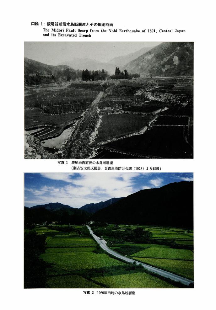
1 0 0 0 OA 根尾谷断層水鳥断層崖とその掘削断面
- 著者
- 佐藤 比呂志 岡田 篤正 松田 時彦 隈元 崇
- 出版者
- 公益社団法人 東京地学協会
- 雑誌
- 地学雑誌 (ISSN:0022135X)
- 巻号頁・発行日
- vol.101, no.7, pp.plate3-plate5, 1992-12-25 (Released:2010-10-13)
1 0 0 0 OA 福井地震に就いて
- 著者
- 河角 廣
- 出版者
- 公益社団法人 東京地学協会
- 雑誌
- 地学雑誌 (ISSN:0022135X)
- 巻号頁・発行日
- vol.57, no.2, pp.93a-94, 1949-03-30 (Released:2009-11-12)
- 著者
- 河角 広
- 出版者
- Tokyo Geographical Society
- 雑誌
- 地学雑誌 (ISSN:0022135X)
- 巻号頁・発行日
- vol.79, no.3, pp.115-138, 1970
- 被引用文献数
- 13
In earlier days most Japanese wanted eagerly to have means of earthquake prediction in order to escape earthquake disaster taking refuge in advance in open spaces since they were almost powerless in encountering the menaces. We are now enabled to long for the mitigation of the disaster by the advancement of science and technology, although we have not yet succeeded to predict the coming of a disastrous earthquake. Our safety thus depend entirely on our effort for the countermeasures against the calamity. But we have only limited allowances for such preparations economically and in time available. It is therefore inevitable to start the preparation from the most important and imminent localities in a country, from the national point of view.<BR>In Japan, according to the writer's witness on the imminence of Southern Kwanto District at the Diet in July, 1964, such preparation work for Tokyo Metropolis was started the next month by a new Earthquake Division of the Disaster Prevention Council of the Metropolis, and several important hazard possibilities of the imminent earthquake have been revealed with the result that similar committees have also been made in other prefectures and cities in the same area as well as in the Central Government of the country.<BR>In this paper the writer intended to give the ground for his assertion of the imminence of a disastrous earthquake giving proofs of the periodicity of such calamities on the statistical and historical analyses, and made some comments on the possible consequences and major problems in the countermeasures to cope with the conceived disaster as revealed by the studies made on the national and metropolitan levels.<BR>In view of the importance, interest and the space allowance, only the proofs of the periodicity in the recurrence of destructive earthquakes in the district concerned are summarised in this abstract.<BR>Historical earthquakes in and around Kwanto District as shown in the map (Fig. 2.1) were examined and those which were destructive at Kamakura or presumable as such from the standard intensity-distance-magnitude curve were selected and listed in Table 1.1. Periodicities of these earthquakes were analysed statistically. Similar analyses were also applied to the earthquakes experienced in Tokyo which are listed in Table 2.2. A definite period τ of 69 years (besides a few integral multiples of this period) was clearly found. The methods used in the above analyses were by means of (1) Fourier transforms (Fig. 1.1), (2) autocorrelation functions (Figs. 1.3 and 1.4) and (3) historical examinations of the number of cases when no destructive earthquakes took place within the standard deviation +√ ξ<SUP>2</SUP> from the year t<SUB>p</SUB> when a destructive earthquake was expected to occur from the periodicity. Test of persistence of the period was also made by means of the theory of random walks consisting of Fourier amplitudes in successive periods (Figs. 1.5 a and b). Rayleigh-Schuster's criterion (Formula 1.3) that is the probability of obtaining the actual Fourier amplitude on the assumption of no periodicity or the resultant distance of above mentioned random walks gave the values of the probability equal to 0.06% and 0.03% for Kamakura and Tokyo respectively. In comparison to usual value of 5 or 10% for recognizing periodicity in geophysical phenomena, the smallness of the above values is more than enough to disprove the non-existence of the periodicity of 69 years in the recurrence of destructive earthquakes in the districts under consideration.
1 0 0 0 OA 阿蘇火山中央火口丘群のテフラ層序と爆発的噴火史
- 著者
- 長岡 信治 奥野 充
- 出版者
- 公益社団法人 東京地学協会
- 雑誌
- 地学雑誌 (ISSN:0022135X)
- 巻号頁・発行日
- vol.113, no.3, pp.425-429, 2004-04-25 (Released:2009-11-12)
- 参考文献数
- 24
- 被引用文献数
- 1
1 0 0 0 OA キラウエア火山の噴火
- 著者
- 早川 由紀夫
- 出版者
- 公益社団法人 東京地学協会
- 雑誌
- 地学雑誌 (ISSN:0022135X)
- 巻号頁・発行日
- vol.107, no.3, pp.Plate1-Plate2, 1998-06-25 (Released:2009-11-12)
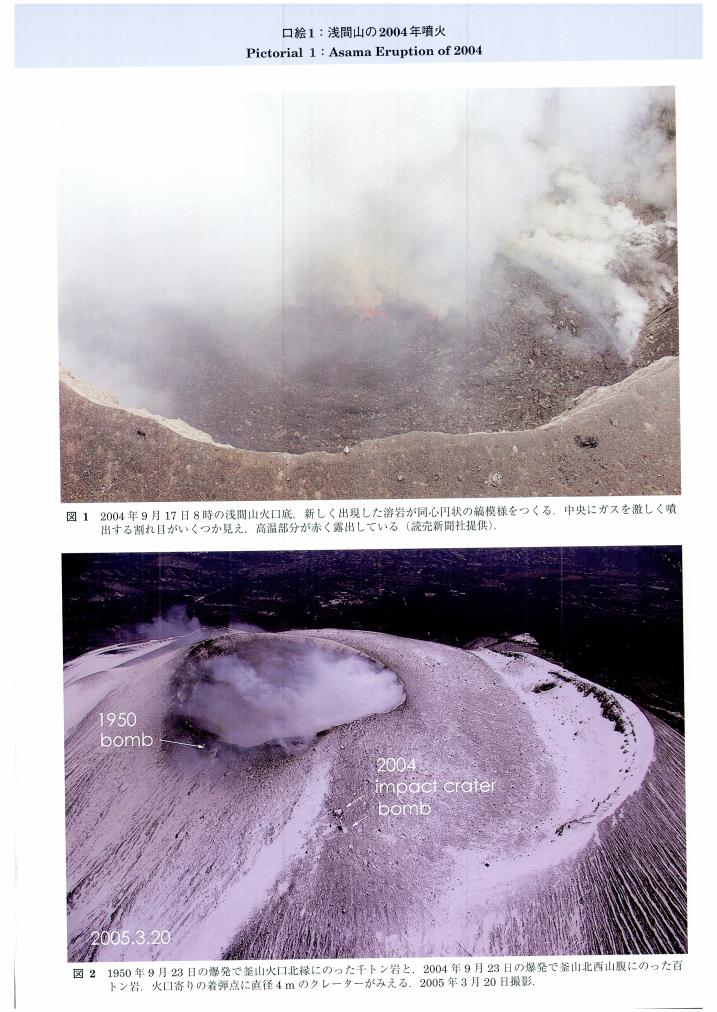
1 0 0 0 OA 浅間山の2004年噴火
- 著者
- 早川 由紀夫
- 出版者
- 公益社団法人 東京地学協会
- 雑誌
- 地学雑誌 (ISSN:0022135X)
- 巻号頁・発行日
- vol.115, no.2, pp.Plate3-Plate4, 2006-04-25 (Released:2009-11-12)
1 0 0 0 OA 北側からみた浅間山と鬼押出し溶岩流
- 著者
- 白尾 元理 早川 由紀夫
- 出版者
- 公益社団法人 東京地学協会
- 雑誌
- 地学雑誌 (ISSN:0022135X)
- 巻号頁・発行日
- vol.104, no.4, pp.Plate1-Plate2, 1995-08-25 (Released:2009-11-12)
1 0 0 0 OA 日本およびハワイにおける玄武岩マグマの発生機構・化学組成の相違
- 著者
- 久野 久
- 出版者
- 公益社団法人 東京地学協会
- 雑誌
- 地学雑誌 (ISSN:0022135X)
- 巻号頁・発行日
- vol.73, no.5, pp.279-280, 1964-10-30 (Released:2009-11-12)
- 被引用文献数
- 1
Basalt magmas in Japan range in composition from tholeiite, passing through high-alumina basalt, to alkali basalt. Picrite basalt related to either of these three basalt magmas is scarcely represented. In Hawaii, both tholeiite and alkali basalt are closely associated with picrite basalt having bulk compositions intermediate between the ordinary basalt and peridotite. The Japanese basalt magmas are supposed to be produced by sudden release of stress attending the generation of the intermediate to deep-focus earthquakes. In such a case, there may be a certain limitation of the heat energy supply for melting the mantle peridotite ; only a few per cent of the peridotite would be melted to form the basalt magmas.The Hawaiian basalt magmas are supposed to be produced by the heat transfer due to convection current within the mantle. In such a case, there would be less limitation of the heat energy supply for melting ; a greater per cent of the peridotite would be melted, resulting in the production of picrite basalt magmas.
1 0 0 0 南極地域の地質
- 著者
- 立見 辰雄 菊池 徹 久野 久
- 出版者
- Tokyo Geographical Society
- 雑誌
- 地学雑誌 (ISSN:0022135X)
- 巻号頁・発行日
- vol.66, no.1, pp.17-33, 1957
1 0 0 0 OA 表層堆積物の変形構造からみた深谷断層系綾瀬川断層北部の後期更新世以降の活動史
- 著者
- 須貝 俊彦 水野 清秀 八戸 昭一 中里 裕臣 石山 達也 杉山 雄一 細矢 卓志 松島 紘子 吉田 英嗣 山口 正秋 大上 隆史
- 出版者
- 公益社団法人 東京地学協会
- 雑誌
- 地学雑誌 (ISSN:0022135X)
- 巻号頁・発行日
- vol.116, no.3-4, pp.394-409, 2007-08-25 (Released:2009-11-12)
- 参考文献数
- 26
- 被引用文献数
- 5 9
The northern Ayasegawa fault is a part of the Fukaya fault system, which is the longest active fault in the Kanto district. The paleoseismology of the northern Ayasegawa fault was revealed by a combination of arrayed boring and ground penetrating radar (GPR) survey. The northern Ayasegawa fault produced a fold scarp with the NW-SE direction running along the boundary between the Oomiya 2 (O2) surface and fluvial lowland. The O2 was formed in Marine Isotope Stage 5a, and was slightly deformed with a wide warping zone. Sixteen sediment cores arrayed across the warping zone contain a series of tephra layers such as Hk-TP (ca. 60-65 ka), KMP, AT (26-29 ka), As-BP group (20-25 ka), and As-YP (15-16.5 ka). These key beds except Hk-TP were deposited and deformed parallel to each other, suggesting that no faulting events occurred between KMP and As-VP fall. The timing of the last faulting event is after the As-YP fall, and is probably younger than 10 ka based on an interpretation of GPR profiles and 14C ages. KMP should be deposited horizontally because it intervened in the peaty silt layer, which accumulated conformably on lacustrine deposits overlapping the fold scarp. Thus, the KMP horizon roughly indicates the vertical offset produced by the events occurred after the As YP fall. The events were probably singular, and the last one formed a vertical offset of more than 4 m. The older event occurred at around 70 ka between Hk-TP fall and O2 formation. Vertical deformation of the O2 was at least 7 m, indicating the possibility that the vertical offset caused by the penultimate event is at least 3 m. The vertical slip per event might reach 5 m, and the average vertical slip rate is nearly 0.1 mm/yr because the warping zone detected by the arrayed boring above is within the flexure zone shown by the P-wave seismic profile. The northern Ayasegawa fault is considered to be a single behavioral segment because of its longer recurrence interval and lower slip rate of 0.1 mm/yr in comparison with those of the other part of the Fukaya fault system.
1 0 0 0 OA 特集号「メタンハイドレート(Part II):探査と資源ポテンシャル」
1 0 0 0 OA 佛國の地理學者ヱリゼ, ルクリユー先生逝く
- 著者
- 田中 阿歌麻呂
- 出版者
- 公益社団法人 東京地学協会
- 雑誌
- 地学雑誌 (ISSN:0022135X)
- 巻号頁・発行日
- vol.17, no.8, pp.579-584, 1905-08-15 (Released:2010-10-13)
- 被引用文献数
- 1
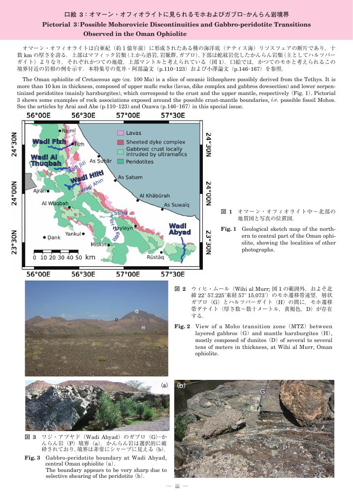
1 0 0 0 OA 口絵3:オマーン・オフィオライトに見られるモホおよびガブロ–かんらん岩境界
- 著者
- 荒井 章司 ピトン マリ
- 出版者
- 公益社団法人 東京地学協会
- 雑誌
- 地学雑誌 (ISSN:0022135X)
- 巻号頁・発行日
- vol.117, no.1, pp.iii-viii, 2008-02-25 (Released:2010-02-10)
1 0 0 0 日本の大地震に就きて
- 著者
- 大森 房吉
- 出版者
- Tokyo Geographical Society
- 雑誌
- 地学雑誌 (ISSN:0022135X)
- 巻号頁・発行日
- vol.13, no.1, pp.18-24, 1901
1 0 0 0 OA 旅行ガイドブックにみる富士山観光のイメージ変化
- 著者
- 有馬 貴之
- 出版者
- 公益社団法人 東京地学協会
- 雑誌
- 地学雑誌 (ISSN:0022135X)
- 巻号頁・発行日
- vol.124, no.6, pp.1033-1045, 2015-12-25 (Released:2016-01-27)
- 参考文献数
- 18
- 被引用文献数
- 2 8
Mass-information media such as guidebooks, novels, movies, and TV dramas present images of tourist areas. This research aims to investigate changes in the content of one guidebook series concerning Mt. Fuji. Mt. Fuji offers many tourist attractions, including climbing the mountain, viewing it, and shopping in its vicinity. The content featured over the 20 years during which the guidebook series has been published is divided into four periods, which are characterised as follows: sightseeing period (1st period: 1995), leisure and activity period (2nd period: 1996 to 1999), climbing period (3rd period: 2000 to 2008), and climbing and general activities period (4th period: 2009 to 2014). During the 1st period, the word “resort” was important in the guidebooks' content, crafting an image of Mt. Fuji tourism that was led by a resort boom in Japan. The words “leisure,” “history,” and “nature” acquired significance in the 2nd period, when content concerning some activities increased in the guidebooks against the background of a connection between tourism and regional promotion. Guidebooks of the 3rd period heavily used imagery of climbing to characterise Mt. Fuji tourism, with the words “entrance” and “climbing” appearing frequently. This period coincided with a generational transition among climbers, during which there was an increase in Japan of younger climbers and female climbers. During the 4th period, climbing remained the most significant topic of the guidebooks; however, words related to recent Japanese tourism topics, such as “B-grade” “gourmet” “local” and “holy place” took important positions alongside the topic of climbing, because B-grade gourmet products within the Mt. Fuji region such as pan-fried noodles in Fujinomiya city became famous during the 2000s. As a whole, the content of the tourism guidebooks over the years illustrates changes in perceptions of Mt. Fuji from diverse and general images of leisure and pleasure to specific images of climbing.
- 著者
- 北村 彩子 泉 岳樹 松山 洋
- 出版者
- 公益社団法人 東京地学協会
- 雑誌
- 地学雑誌 (ISSN:0022135X)
- 巻号頁・発行日
- vol.113, no.4, pp.495-511, 2004-08-25 (Released:2009-11-12)
- 参考文献数
- 29
- 被引用文献数
- 2
The thermal infrared images observed by satellites represent integral of radiations from both surface and atmosphere. This has been pointed out qualitatively, however, it has not been clarified quantitatively. Using Landsat-5 TM images (Kanto scene, Path107, Row35), this study quantitatively investigated the ratio of the radiant flux densities of surface temperature and those of air temperature. A multiple regression analysis was applied in this investigation. Four daytime scenes of the thermal infrared images of Landsat-5 TM (28 Feb1992, 25 Feb 1997, 13 Dec 1998, 30 Jan 1999, all were fine), and meteorological data in meteorological observatories, AMeDAS stations and Terrestrial Environment Research Center, University of Tsukuba were used for the analysis. Generally, surface temperature around10 : 00 JST is not observed when Landsat passes the study area, so the diurnal variation of thesurface temperature and energy budget at each site was calculated by the method of Kondo (1992) who set exchange coefficient constant throughout a day.It was clarified that the radiant flux densities of surface temperature and those of air temperature equally contribute to the radiant flux densities of brightness temperature observed by Landsat-5 TM, except for a case of strong wind since the constant value of exchange coefficient was not appropriate in this case. In the case of 13 Dec 1998, correlation between brightness temperature and air temperature, obtained in this study (r=0.71) was better than that of Yan and Mikami (2002) (r=0.53) who analyzed the same thermal infrared images. This was due to the difference of the area studied. In this case, correlation betweenradiant flux densities of brightness temperature and those of air temperature were also 0.71. Moreover, the multiple correlation coefficient among brightness temperature, surface temperature and air temperature (r=0.76), and radiant flux densities of brightness temperature, that of both surface temperature and air temperature (r=0.76) was better than the single correlation coefficients between brightness temperature and air temperature, and radiant flux densities of them. Since AIC (Akaike's Information Criterion) of the multiple correlation analysis was smaller than that of the single correlation analysis, this study statistically showed that the radiant flux densities of brightness temperature observed byLandsat-5 TM represented equal contribution of both surface temperature and air temperature.
1 0 0 0 OA 相模湾北西部地域の地震テクトニクス
- 著者
- 松田 時彦
- 出版者
- 公益社団法人 東京地学協会
- 雑誌
- 地学雑誌 (ISSN:0022135X)
- 巻号頁・発行日
- vol.102, no.4, pp.354-364, 1993-08-25 (Released:2010-11-18)
- 参考文献数
- 45
- 被引用文献数
- 3 2


