2 0 0 0 OA 海底活断層から発生する大地震の予測精度向上のための変動地形学的研究
- 著者
- 澤 祥 坂上 寛之 隈元 崇 渡辺 満久 鈴木 康弘 田力 正好 谷口 薫 廣内 大助 松多 信尚 安藤 俊人 佐藤 善輝 石黒 聡士 内田 主税
- 出版者
- Japanese Society for Active Fault Studies
- 雑誌
- 活断層研究 (ISSN:09181024)
- 巻号頁・発行日
- vol.2006, no.26, pp.121-136, 2006
We conducted a tectonic geomorphological survey along the northern part of the Itoigawa-Shizuoka Tectonic Line (ISTL) with support from the Ministry of Education, Culture, Sports, Science and Technology of Japan as one of the intensive survey on ISTL fault system. This survey aims to clarify the detailed distribution of the slip rates of this fault system, which provides the essential data set to predict the coseismic behavior and to estimate the strong ground motion simulation. In order to achieve this purpose, the active fault traces are newly mapped along the northern part of the ISTL through interpretations of aerial photographs archived in the 1940s and 1960s at scales of 1: 10,000 and 1: 20,000, respectively. This aerial photo analysis was also supplemented and reinforced by field observations.<BR>One of the remarkable results by using this data set is a large number of, here 84, photogrammetrically measured landform transections to quantify the tectonic deformations. We could calculate vertical slip rates of the faults at 74 points, based on the estimated ages of terraces (H: 120 kyrs, M: 50-100 kyrs, Ll: 10-20 kyrs, L2: 4-7 kyrs, L3: 1-2 kyrs). The vertical slip rates distributed in the northern part of the study area show 0.2-5.5 mm/yr on the L terraces (less than 20 kyrs) and 0.05-0.9 mm/yr on the M and H terraces (more than 50 kyrs). The vertical slip rates of the faults located in the central and southern part of the study area are 0.2-3.1 mm/yr.
1 0 0 0 OA 地震調査委員会の活断層評価の結果を基にした地震発生間隔のばらつきの解析
- 著者
- 石関 隆幸 隈元 崇
- 出版者
- 一般社団法人 日本活断層学会
- 雑誌
- 活断層研究 (ISSN:09181024)
- 巻号頁・発行日
- vol.2007, no.27, pp.63-73, 2007-06-30 (Released:2012-11-13)
- 参考文献数
- 14
bility to the BPT model. As a result, we conclude that case (c) is the most realistic model by the AIC procedure.Also, we simulated the value by randomly selecting the event occurrence between the range of the recurrence interval and verified the variable estimated from the mean recurrence interval. As a result, the value 0.24 estimated from the four active faults or the value 0.42 estimated in this study is mostly smaller than the average value that can be practically estimated from data. Also, we show some case that is possible to estimate the variable more accurately by considering the probability density distribution of the event occurrence.
1 0 0 0 OA 南海トラフ南方の銭洲断層系活断層と歴史地震
- 著者
- 中田 高 徳山 英一 隈元 崇 室井 翔太 渡辺 満久 鈴木 康弘 後藤 秀昭 西澤 あずさ 松浦 律子
- 出版者
- The Association of Japanese Geographers
- 雑誌
- 日本地理学会発表要旨集
- 巻号頁・発行日
- pp.240, 2013 (Released:2013-09-04)
2011年東北地方太平洋沖地震以降,中央防災会議によって,南海トラフ沿いの巨大地震と津波の想定がなされているが,トラフ外れた海底活断層については詳しい検討は行われていない.縁者らは,詳細な数値標高モデルから作成した立体視可能な画像を判読し,南海トラフ東部の南方に位置する銭洲断層系活断層の位置・形状を明らかしたうえで.その特徴および歴史地震との関連を検討する.
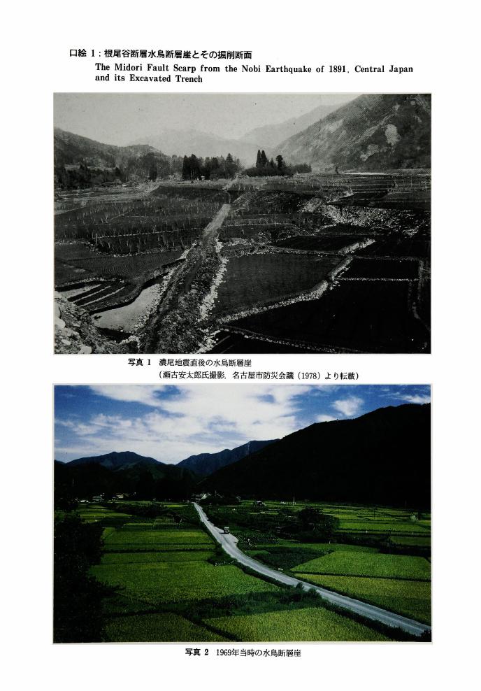
1 0 0 0 OA 根尾谷断層水鳥断層崖とその掘削断面
- 著者
- 佐藤 比呂志 岡田 篤正 松田 時彦 隈元 崇
- 出版者
- 公益社団法人 東京地学協会
- 雑誌
- 地学雑誌 (ISSN:0022135X)
- 巻号頁・発行日
- vol.101, no.7, pp.plate3-plate5, 1992-12-25 (Released:2010-10-13)
1 0 0 0 活断層から発生する地震の予測精度向上のための地形学的研究
本研究は,従来の活断層研究により積み重ねられてきた断層の分布や構造に関する静的な断層モデルに対して,地震時の活断層の挙動に関する動的モデルを構築することを主たる目的とした.そのために,1)活断層の位置,形状,変位速度の分布を解明,2)断層変位量計測の新たな手法の開発,3)日本列島の活断層の変位量データベースの作成,4)活断層の挙動に関する動的モデルの検討,を具体的に行った.その結果,議論の多い活断層の不連続部や末端部において,大縮尺空中写真判読による見直しを実施し,これまで活断層の存在が確かではなかった岩国断層や西部や北九州地域の活断層をはじめ多くの活断層について,詳細な位置,形状を確定した.横ずれタイプと逆断層タイプのそれぞれの典型である阿寺断層および横手盆地東縁活断層系について,独自に空中レーザープロファイラーによるDEMを取得し,断層変位地形の把握,断層変位量の計測について,手法の利点と問題点を具体的に検討した結果,レーザー計測データを用いた断層変位地形の立体化が活断層認定に有効であり,正確な変位量の把握には変動地形学的手法の併用が不可欠であることが明らかになった.また,GPS地形測量装置や簡易レーザー計測装置(Handy Station)を用いた断層変位量計測を実施し,その有効性を検討した.さらに,既存の文献に記載された断層変位量などをもとに主要98活断層(帯)の活断層変位量データベースを構築した.これをもとに断層変位量分布の特徴を検討し,幾つかの活断層(帯)について地下のアスペリティの位置を推定した.これらの情報と活断層の幾何学形状から推定した断層の破壊開始点をもとに,主要活断層帯から発生する地震の動的モデルの試案を提示した.
