1 0 0 0 OA 阿蘇火山中央火口丘群のテフラ層序と爆発的噴火史
- 著者
- 長岡 信治 奥野 充
- 出版者
- 公益社団法人 東京地学協会
- 雑誌
- 地学雑誌 (ISSN:0022135X)
- 巻号頁・発行日
- vol.113, no.3, pp.425-429, 2004-04-25 (Released:2009-11-12)
- 参考文献数
- 24
- 被引用文献数
- 1
1 0 0 0 OA キラウエア火山の噴火
- 著者
- 早川 由紀夫
- 出版者
- 公益社団法人 東京地学協会
- 雑誌
- 地学雑誌 (ISSN:0022135X)
- 巻号頁・発行日
- vol.107, no.3, pp.Plate1-Plate2, 1998-06-25 (Released:2009-11-12)
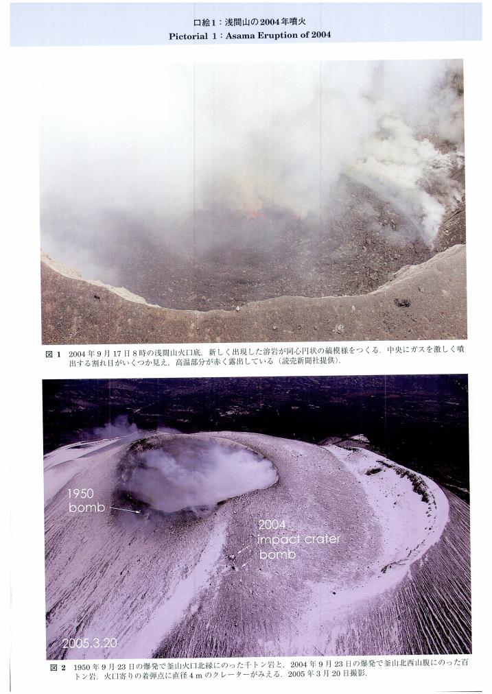
1 0 0 0 OA 浅間山の2004年噴火
- 著者
- 早川 由紀夫
- 出版者
- 公益社団法人 東京地学協会
- 雑誌
- 地学雑誌 (ISSN:0022135X)
- 巻号頁・発行日
- vol.115, no.2, pp.Plate3-Plate4, 2006-04-25 (Released:2009-11-12)
1 0 0 0 OA 北側からみた浅間山と鬼押出し溶岩流
- 著者
- 白尾 元理 早川 由紀夫
- 出版者
- 公益社団法人 東京地学協会
- 雑誌
- 地学雑誌 (ISSN:0022135X)
- 巻号頁・発行日
- vol.104, no.4, pp.Plate1-Plate2, 1995-08-25 (Released:2009-11-12)
1 0 0 0 OA 日本およびハワイにおける玄武岩マグマの発生機構・化学組成の相違
- 著者
- 久野 久
- 出版者
- 公益社団法人 東京地学協会
- 雑誌
- 地学雑誌 (ISSN:0022135X)
- 巻号頁・発行日
- vol.73, no.5, pp.279-280, 1964-10-30 (Released:2009-11-12)
- 被引用文献数
- 1
Basalt magmas in Japan range in composition from tholeiite, passing through high-alumina basalt, to alkali basalt. Picrite basalt related to either of these three basalt magmas is scarcely represented. In Hawaii, both tholeiite and alkali basalt are closely associated with picrite basalt having bulk compositions intermediate between the ordinary basalt and peridotite. The Japanese basalt magmas are supposed to be produced by sudden release of stress attending the generation of the intermediate to deep-focus earthquakes. In such a case, there may be a certain limitation of the heat energy supply for melting the mantle peridotite ; only a few per cent of the peridotite would be melted to form the basalt magmas.The Hawaiian basalt magmas are supposed to be produced by the heat transfer due to convection current within the mantle. In such a case, there would be less limitation of the heat energy supply for melting ; a greater per cent of the peridotite would be melted, resulting in the production of picrite basalt magmas.
1 0 0 0 南極地域の地質
- 著者
- 立見 辰雄 菊池 徹 久野 久
- 出版者
- Tokyo Geographical Society
- 雑誌
- 地学雑誌 (ISSN:0022135X)
- 巻号頁・発行日
- vol.66, no.1, pp.17-33, 1957
1 0 0 0 OA 表層堆積物の変形構造からみた深谷断層系綾瀬川断層北部の後期更新世以降の活動史
- 著者
- 須貝 俊彦 水野 清秀 八戸 昭一 中里 裕臣 石山 達也 杉山 雄一 細矢 卓志 松島 紘子 吉田 英嗣 山口 正秋 大上 隆史
- 出版者
- 公益社団法人 東京地学協会
- 雑誌
- 地学雑誌 (ISSN:0022135X)
- 巻号頁・発行日
- vol.116, no.3-4, pp.394-409, 2007-08-25 (Released:2009-11-12)
- 参考文献数
- 26
- 被引用文献数
- 5 9
The northern Ayasegawa fault is a part of the Fukaya fault system, which is the longest active fault in the Kanto district. The paleoseismology of the northern Ayasegawa fault was revealed by a combination of arrayed boring and ground penetrating radar (GPR) survey. The northern Ayasegawa fault produced a fold scarp with the NW-SE direction running along the boundary between the Oomiya 2 (O2) surface and fluvial lowland. The O2 was formed in Marine Isotope Stage 5a, and was slightly deformed with a wide warping zone. Sixteen sediment cores arrayed across the warping zone contain a series of tephra layers such as Hk-TP (ca. 60-65 ka), KMP, AT (26-29 ka), As-BP group (20-25 ka), and As-YP (15-16.5 ka). These key beds except Hk-TP were deposited and deformed parallel to each other, suggesting that no faulting events occurred between KMP and As-VP fall. The timing of the last faulting event is after the As-YP fall, and is probably younger than 10 ka based on an interpretation of GPR profiles and 14C ages. KMP should be deposited horizontally because it intervened in the peaty silt layer, which accumulated conformably on lacustrine deposits overlapping the fold scarp. Thus, the KMP horizon roughly indicates the vertical offset produced by the events occurred after the As YP fall. The events were probably singular, and the last one formed a vertical offset of more than 4 m. The older event occurred at around 70 ka between Hk-TP fall and O2 formation. Vertical deformation of the O2 was at least 7 m, indicating the possibility that the vertical offset caused by the penultimate event is at least 3 m. The vertical slip per event might reach 5 m, and the average vertical slip rate is nearly 0.1 mm/yr because the warping zone detected by the arrayed boring above is within the flexure zone shown by the P-wave seismic profile. The northern Ayasegawa fault is considered to be a single behavioral segment because of its longer recurrence interval and lower slip rate of 0.1 mm/yr in comparison with those of the other part of the Fukaya fault system.
1 0 0 0 OA 特集号「メタンハイドレート(Part II):探査と資源ポテンシャル」
1 0 0 0 OA 佛國の地理學者ヱリゼ, ルクリユー先生逝く
- 著者
- 田中 阿歌麻呂
- 出版者
- 公益社団法人 東京地学協会
- 雑誌
- 地学雑誌 (ISSN:0022135X)
- 巻号頁・発行日
- vol.17, no.8, pp.579-584, 1905-08-15 (Released:2010-10-13)
- 被引用文献数
- 1
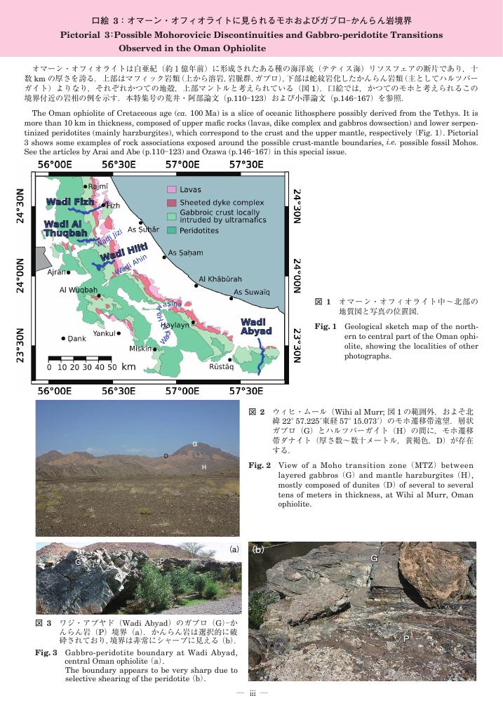
1 0 0 0 OA 口絵3:オマーン・オフィオライトに見られるモホおよびガブロ–かんらん岩境界
- 著者
- 荒井 章司 ピトン マリ
- 出版者
- 公益社団法人 東京地学協会
- 雑誌
- 地学雑誌 (ISSN:0022135X)
- 巻号頁・発行日
- vol.117, no.1, pp.iii-viii, 2008-02-25 (Released:2010-02-10)
1 0 0 0 日本の大地震に就きて
- 著者
- 大森 房吉
- 出版者
- Tokyo Geographical Society
- 雑誌
- 地学雑誌 (ISSN:0022135X)
- 巻号頁・発行日
- vol.13, no.1, pp.18-24, 1901
1 0 0 0 OA 旅行ガイドブックにみる富士山観光のイメージ変化
- 著者
- 有馬 貴之
- 出版者
- 公益社団法人 東京地学協会
- 雑誌
- 地学雑誌 (ISSN:0022135X)
- 巻号頁・発行日
- vol.124, no.6, pp.1033-1045, 2015-12-25 (Released:2016-01-27)
- 参考文献数
- 18
- 被引用文献数
- 2 8
Mass-information media such as guidebooks, novels, movies, and TV dramas present images of tourist areas. This research aims to investigate changes in the content of one guidebook series concerning Mt. Fuji. Mt. Fuji offers many tourist attractions, including climbing the mountain, viewing it, and shopping in its vicinity. The content featured over the 20 years during which the guidebook series has been published is divided into four periods, which are characterised as follows: sightseeing period (1st period: 1995), leisure and activity period (2nd period: 1996 to 1999), climbing period (3rd period: 2000 to 2008), and climbing and general activities period (4th period: 2009 to 2014). During the 1st period, the word “resort” was important in the guidebooks' content, crafting an image of Mt. Fuji tourism that was led by a resort boom in Japan. The words “leisure,” “history,” and “nature” acquired significance in the 2nd period, when content concerning some activities increased in the guidebooks against the background of a connection between tourism and regional promotion. Guidebooks of the 3rd period heavily used imagery of climbing to characterise Mt. Fuji tourism, with the words “entrance” and “climbing” appearing frequently. This period coincided with a generational transition among climbers, during which there was an increase in Japan of younger climbers and female climbers. During the 4th period, climbing remained the most significant topic of the guidebooks; however, words related to recent Japanese tourism topics, such as “B-grade” “gourmet” “local” and “holy place” took important positions alongside the topic of climbing, because B-grade gourmet products within the Mt. Fuji region such as pan-fried noodles in Fujinomiya city became famous during the 2000s. As a whole, the content of the tourism guidebooks over the years illustrates changes in perceptions of Mt. Fuji from diverse and general images of leisure and pleasure to specific images of climbing.
- 著者
- 北村 彩子 泉 岳樹 松山 洋
- 出版者
- 公益社団法人 東京地学協会
- 雑誌
- 地学雑誌 (ISSN:0022135X)
- 巻号頁・発行日
- vol.113, no.4, pp.495-511, 2004-08-25 (Released:2009-11-12)
- 参考文献数
- 29
- 被引用文献数
- 2
The thermal infrared images observed by satellites represent integral of radiations from both surface and atmosphere. This has been pointed out qualitatively, however, it has not been clarified quantitatively. Using Landsat-5 TM images (Kanto scene, Path107, Row35), this study quantitatively investigated the ratio of the radiant flux densities of surface temperature and those of air temperature. A multiple regression analysis was applied in this investigation. Four daytime scenes of the thermal infrared images of Landsat-5 TM (28 Feb1992, 25 Feb 1997, 13 Dec 1998, 30 Jan 1999, all were fine), and meteorological data in meteorological observatories, AMeDAS stations and Terrestrial Environment Research Center, University of Tsukuba were used for the analysis. Generally, surface temperature around10 : 00 JST is not observed when Landsat passes the study area, so the diurnal variation of thesurface temperature and energy budget at each site was calculated by the method of Kondo (1992) who set exchange coefficient constant throughout a day.It was clarified that the radiant flux densities of surface temperature and those of air temperature equally contribute to the radiant flux densities of brightness temperature observed by Landsat-5 TM, except for a case of strong wind since the constant value of exchange coefficient was not appropriate in this case. In the case of 13 Dec 1998, correlation between brightness temperature and air temperature, obtained in this study (r=0.71) was better than that of Yan and Mikami (2002) (r=0.53) who analyzed the same thermal infrared images. This was due to the difference of the area studied. In this case, correlation betweenradiant flux densities of brightness temperature and those of air temperature were also 0.71. Moreover, the multiple correlation coefficient among brightness temperature, surface temperature and air temperature (r=0.76), and radiant flux densities of brightness temperature, that of both surface temperature and air temperature (r=0.76) was better than the single correlation coefficients between brightness temperature and air temperature, and radiant flux densities of them. Since AIC (Akaike's Information Criterion) of the multiple correlation analysis was smaller than that of the single correlation analysis, this study statistically showed that the radiant flux densities of brightness temperature observed byLandsat-5 TM represented equal contribution of both surface temperature and air temperature.
1 0 0 0 OA 相模湾北西部地域の地震テクトニクス
- 著者
- 松田 時彦
- 出版者
- 公益社団法人 東京地学協会
- 雑誌
- 地学雑誌 (ISSN:0022135X)
- 巻号頁・発行日
- vol.102, no.4, pp.354-364, 1993-08-25 (Released:2010-11-18)
- 参考文献数
- 45
- 被引用文献数
- 3 2
1 0 0 0 OA プレート境界断層が海溝から地震発生深度にかけて発達する際の流体挙動
- 著者
- 氏家 恒太郎 山口 飛鳥 木村 学 久光 敏夫 平 朝彦
- 出版者
- 公益社団法人 東京地学協会
- 雑誌
- 地学雑誌 (ISSN:0022135X)
- 巻号頁・発行日
- vol.115, no.3, pp.353-366, 2006-06-25 (Released:2009-11-12)
- 参考文献数
- 34
- 被引用文献数
- 3 3
Fluid behavior during the evolution of the plate boundary fault (pbf) from a trench to seismogenic depths is the central problem when evaluating the relationship between fluids and seismicity in subduction zones. Ocean Drilling Program Legs 190 and 196 at the toe region of the Nankai accretionary margin reveal that fluid-filled dilatant fractures and underconsolidated underthrust sediments lead to an elevated fluid pressure in and below the pbf, respectively. The pbf with elevated fluid pressure extends down-dip to 35 km, resulting in the absence of seismic behavior at shallow depths and mechanical decoupling between accreted and underthrust sediments. Underconsolidated underthrust sediments are primarily caused by rapid tectonic loading compared to the rate of fluid escape in underthrust sediments and secondarily by a lowpermeability cap due to the compactively deformed pbf. Fluid-filled dilatant fractures represent the overconsolidate state within the pbf, which is caused by the generation of high fluid pressure after compactive deformations.The exhumed plate boundary rocks (i.e., tectonic melange) in the Shimanto accretionary complex indicate that the underthrust sediments became rocks due to dewatering, pressure solution, and other diagenetic reactions, thus acquiring elastic strength. The pbf in the upper part of the seismogenic depths was weak due to elevated fluid pressure, this facilitated the downward step of the pbf and the underplating of underthrust rocks. The pbf under low effective stress was unlikely to nucleate the instability; however the fluid-related repeated deformations, which probably reflect the seismic cycle in the subduction zone, could be recorded. The coseismic deformations were attributed to hydraulic implosion breccias, injection of ultracataclasite, and fluid inclusion stretching in the pbf. Implosion breccias suggest rapid depressurization associated with the passage of the rupture through dilational jog. Other deformations represent shear heating and fluidization along the narrow ultracataclasite layer, which could enhance the propagation of instability at the pbf in the upper parts of the seismogenic depths.
1 0 0 0 OA 大室山がつくった伊豆高原と城ヶ崎海岸
- 出版者
- 公益社団法人 東京地学協会
- 雑誌
- 地学雑誌 (ISSN:0022135X)
- 巻号頁・発行日
- vol.119, no.1, pp.Cover01_1-Cover01_2, 2010-02-15 (Released:2010-05-21)
伊豆半島の東半分およびその沖合の相模湾底に100個程度の単成火山の群れである伊豆東部火山群が分布している.大室山(標高580m.写真右上の薄茶色の小山)は,底径1km,比高300mほどの美しいプリン状のスコリア丘で,およそ4,000年前の噴火によってできた.山頂には直径250m,深さ40mのスリバチ状の火口があり,観光リフトによって簡単に登山・散策できる.山頂からの360度のパノラマは見事である. 大室山から流出した溶岩は北方・東方・南方へと流れ下り,地形の凹凸を埋めて伊豆高原(写真中央から右にかけての台地)をつくるとともに,幅4kmほどの範囲で相模湾に流れこんで城ヶ崎海岸(写真左から下にかけての凹凸の激しい海岸)をつくった.海岸ぞいでは,柱状節理・溶岩じわなどのさまざまな溶岩流の造形を観察することができる.写真左上の山は,第四紀火山のひとつである天城山.(写真:白尾元理,2010年1月7日撮影;解説:小山真人)
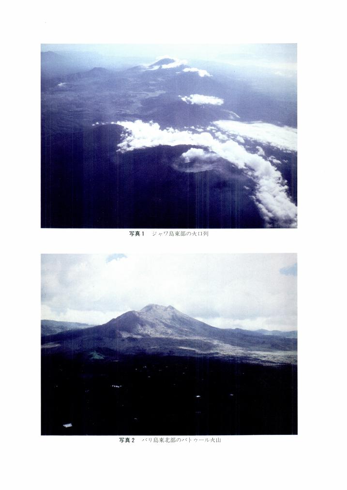
1 0 0 0 OA ジャワとバリの火山
- 著者
- 尾池 和夫
- 出版者
- 公益社団法人 東京地学協会
- 雑誌
- 地学雑誌 (ISSN:0022135X)
- 巻号頁・発行日
- vol.97, no.7, pp.Plate1-Plate4, 1988-12-25 (Released:2009-11-12)
1 0 0 0 OA インドネシア非火山性外弧のオフィオライト
- 著者
- 石川 晃 金子 慶之 太田 努 磯崎 行雄
- 出版者
- 公益社団法人 東京地学協会
- 雑誌
- 地学雑誌 (ISSN:0022135X)
- 巻号頁・発行日
- vol.120, no.1, pp.52-64, 2011-02-25 (Released:2011-05-20)
- 参考文献数
- 59
- 被引用文献数
- 2 2 3
The western Pacific region, where the Eurasia, Australia, and Pacific plates currently interact, has been recognized as an important site for constraining the origins and emplacement of ophiolites (particularly for island-arc or supra-subduction zone types), because the spatial distribution of oceanic micro-plates and numerous ophiolitic rocks along their convergent margins infers possible genetic linkages among them. Mafic-ultramafic rocks distributed in the Timor-Tanimbar island chain, eastern Indonesia may be a good example of the on-going emplacement of the marginal basin lithosphere on the continental margin in the arc-continent collision zone, and are recognized as a possible modern analogue for Mesozoic Tethyan-type ophiolites (e.g. Troodos and Oman) in the Alpine-Himalayan orogenic system. Geological occurrence suggests that the buoyant subduction of the Australian continent uplifted fragments of newly formed mantle-crust section, which extends to neighboring pre-emplaced forearc marginal basins. However, from petrological and geochemical points of view, young pillowed basalt, dolerite, and gabbroic cumulate commonly possess island-arc signatures, whereas structurally underlying peridotites are mostly fertile (lherzolitic) in composition. This suggests that the crustal section is not linked to the underlying mantle by a genetic melt-and-residua relationship, as inferred from the lack of complete succession and the presence of abundant crosscutting structures. This inconsistency leads to the emergence of two contrasting models accounting for the unusual occurrence of a fertile mantle in the forearc setting of the Timor-Tanimbar region: (1) thrust-stacked fragments of the subcontinental mantle originally exhumed in the rifting stage of Australia; (2) depth-related heterogeneities in the lithospheric part of the mantle wedge. We note that the current debates on the origins of fertile lherzolites found throughout the Tethyan sutures and western Pacific regions can be settled through a better understanding of Timor-Tanimbar peridotite masses by age-dating studies employing several radiogenic isotope systematics.
1 0 0 0 OA 活断層研究のための地層抜き取り装置 (Geo-slicer)
- 著者
- 中田 高 島崎 邦彦
- 出版者
- 公益社団法人 東京地学協会
- 雑誌
- 地学雑誌 (ISSN:0022135X)
- 巻号頁・発行日
- vol.106, no.1, pp.59-69, 1997-02-25 (Released:2009-11-12)
- 参考文献数
- 4
- 被引用文献数
- 31 53
We invented a completely new simple method and new equipment necessary for high-resolution active fault studies. Vertical thin sections of unconsolidated soil layers are extracted by a newly invented sampler named “Geo-slicer”.Extracted sections can be taken to a laboratory for close examination or can be displayed at a meeting or even stored for future re-examinations (Fig. 1). This method enables us to carry on high-resolution analyses not only in active fault studies but also in other fields of Quaternary sciences with less expenditure of time, labor and money.We made three different-sized Geo-slicers and tested them successfully in the field. A Geo-slicer is made of steel and has a simple structure composed of a box and its shutter (Figs. 2 and 3). Several devices are implemented to the box and the shutter, such as wedge-shaped side walls and a stopper at the bottom of the box for easy pull-out of the equipment and steady-holding of samples (Fig. 4).For sampling, we firstly intrude the box vertically down into the ground by using a vibro-hammer (Photo 1) and then shutter sliding along the thin slits attached to the both sides of the box, and pull out the equipment containing samples.The extracted layers of sediments are surprisingly undisturbed and show almost the same features as previously observed on trench walls excavated close to the extraction sites (Photos 2 and 3). The largest sample collected by this method is 150 cm wide, 270 cm long (deep) and 8-15 cm thick (Photo 4).This sampling method is far more effective on active fault studies than the conventional trench excavation technique and we will be able to carry out three-dimensional analysis of active faulting, restoration of horizontal fault slips and so on for paleoseismological studies (Fig. 6).
1 0 0 0 OA 日本における地殻構造と地殼変動との関係について
- 著者
- 溝上 恵
- 出版者
- 公益社団法人 東京地学協会
- 雑誌
- 地学雑誌 (ISSN:0022135X)
- 巻号頁・発行日
- vol.73, no.4, pp.224-242, 1964-08-30 (Released:2009-11-12)
- 参考文献数
- 5
As the present crustal structures have been formed by the tectonic movements through the long geological age, problems of the crustal movements must be studied in connection with the information of the present crustal structures obtained from geological, geomorphological and geophysical methods. In this paper, the relation between the crustal structures and the crustal movements in Japanese islands found by geodetic methods is investigated from the following three points.1) The relation between the changes of the intensity of crustal movements with time and those in space.2) The relation between the horizontal variations of the crustal movements and crustal structures.3) The difference of the characteristics of the crustal movements in orogenic regions (Japanese islands) and in continental platform.


