- 著者
- 金田 平太郎 岡田 篤正
- 出版者
- Japanese Society for Active Fault Studies
- 雑誌
- 活断層研究 (ISSN:09181024)
- 巻号頁・発行日
- vol.2002, no.21, pp.73-91, 2002
Surface rupture with maximum right-lateral displacement of 150cm and length of about 1 lkm was observed during the 1943 Tottori earthquake of Mw: 7.0, which struck the eastern Tottori prefecture, southwest Japan. We compiled all the previous reports and papers regarding the surface rupture associated with the earthquake as precise location maps (Appendix 1) and a data table (Appendix 2). We also showed the slip distribution along the surface rupture (Fig.3).<BR>The trace of the 1943 surface rupture exhibited the large step and quite sinuous geometry compared with other strike-slip surface breaks. This observation probably means that the causative fault for Tottori earthquake is at the infant stage on its way of evolution based on the Wesnousky's fault evolution model (Wesnousky,1988). Most of the surface rupture during the earthquake occurred along the geomorphologically detectable active fault (Shikano-Yoshioka active fault system). Thus, we can recognize the possible surface faulting event around the epicentral area based on recent understanding of tectonic geomorpholgy. However, the length of the subsurface seismogenic fault is underestimated by the presently proposed method (Odagiri and Shimazaki,2000) and this sh ould lead to crucial underestimation of the seismic moment and also strong ground motions. The method to estimate the lengt h Df the seismogenic fault must be reestablished.
- 著者
- 斉藤 勝 佃 栄吉 岡田 篤正 古澤 明
- 出版者
- 日本第四紀学会
- 雑誌
- 第四紀研究 (ISSN:04182642)
- 巻号頁・発行日
- vol.36, no.4, pp.277-280, 1997-10-31
- 参考文献数
- 15
- 被引用文献数
- 3 3
和歌山県和歌山市から那賀郡打田町にかけての和泉山脈南麓域には,紀ノ川の支流によって形成された扇状地面が開析され,数段に区分される段丘面が広く分布している.これらの段丘面は,低位段丘(1面,2面),中位段丘(1面,2面)に分類・対比されている(寒川,1977;岡田・寒川,1978;水野ほか,1994).今回の野外調査により,低位段丘2面堆積物中に火山灰層が見いだされたが,この火山灰層は岩石記載学的特徴から,姶良Tn火山灰であることが判明した.姶良Tn火山灰層が挾在することから,和泉山脈南麓域に分布する低位段丘2面は最終氷期極大期頃に形成されたことが判った.<br>低位段丘2面は,中央構造線活断層系に属する根来断層により変位を受けている.根来断層の運動様式は右ずれで,おおむね北側の相対的隆起である.低位段丘2面の離水時期を約2万年とすれば,段丘面や段丘崖の変位量から根来断層の平均変位速度が求められる.これによれば,右ずれは1.8~3.5m/1,000年程度,上下方向は0.3~0.5m/1,000年程度であり,岡田・寒川(1978)が推算した値をほぼ支持する.
1 0 0 0 ニュージーランド北島北東岸の海成段丘と地殻変動
- 著者
- 吉川 虎雄 太田 陽子 米倉 伸之 岡田 篤正 磯 望
- 出版者
- 公益社団法人 日本地理学会
- 雑誌
- 地理学評論 (ISSN:00167444)
- 巻号頁・発行日
- vol.53, no.4, pp.238-262, 1980
- 被引用文献数
- 44
ケルマデック諸島南端部に近いニュージーランド北島プレンティ湾南東岸地域の海成段丘は,上位からマタカオア・オタマロア・テパパ・テアラロアの4段丘に分類される.これらの各段丘は,いずれも海進を示す地形と堆積物とを伴い, 4回の高海面期の存在を示す.段丘をおおうテフラの細分とそれらのフィッション=トラック年代,段丘堆積物の14C年代から,段丘の形成期は,上位のものからそれぞれ約22~23万年前,約12~13万年前,約8~10万年前,約4,000~5,000年前と推定される.<br> 各段丘面の高度分布から,この地域では, (1) 南東から北西への傾動と, (2) 北縁部における北への著しい擁曲とが認められる. (1) は,明瞭な二つのヒンジによって, (1a) 南東部の急な傾動, (1b) 中央部のゆるやかな傾動,および (1c) 北西部の沈降とに分かれる. (1b), (1c) および (2) は,この地域の山地の成長を示すが, (1a)は山地地形とは調和しない.段丘面は古いものほど同じ様式でより著しく変位しているので,第四紀後期には各地域ごとに同じ様式の地殻変動が継続したことを示す. (1a)の隆起や傾動の規模および速さは,ニュージーランドでは最大級の値であり,環太平洋地域の他の島弧一海溝系におけるそれらに匹敵する.このことと,この地域の海溝に対する位置関係から, (1a)はケルマデック海溝内縁に発生する大地震に伴う地殻変動によるものと考えられる.
- 著者
- 堤 浩之 岡田 篤正 中田 高 安藤 雅孝
- 出版者
- 日本地質学会
- 雑誌
- 地質学論集 (ISSN:03858545)
- 巻号頁・発行日
- no.40, pp.p113-127, 1992-12
- 被引用文献数
- 1
四国中央部における中央構造線の活動的なセグメントのひとつ岡村断層のトレンチ発掘調査を1988年3月愛媛県西条市で行なった。断層と地層の変形構造を水平方向に明らかにすることにより断層運動に伴う水平変位量の解明を試みた。壁面で観察される断層の構造は横ずれ断層に共通する特徴を備えている。断層を挟んでの地層の食い違いは右ずれを示し, 断層変位地形から推定される岡村断層の変位のセンスと一致する。地層の変形と^<14>C年代測定結果に基づいて最近2回のイベントを解読した。最新イベントは断層がすべての自然堆積の地層を切断するためその時期を確定することはできないが, それに伴う変位量が右ずれ約5.7 mと求められる。それより1回前のイベントはB.C. 1405~925年にあったと推定される。特定の谷がら供給される地層の年代と供給源との位置関係から過去1万数千年の岡村断層の右ずれ変位速度が6.8 mm/yr以下と推定される。
1 0 0 0 OA 花折断層南部における諸性質と吉田山周辺の地形発達
- 著者
- 岡田 篤正
- 出版者
- 立命館大学歴史都市防災研究センター
- 雑誌
- 歴史都市防災論文集 = 歴史都市防災論文集 (ISSN:18821766)
- 巻号頁・発行日
- vol.1, pp.37-44, 2007-06
1 0 0 0 OA 四国中央部の中央構造線活断層帯の地形・地質・地下構造
- 著者
- 岡田 篤正 杉戸 信彦
- 出版者
- 一般社団法人 日本地質学会
- 雑誌
- 地質学雑誌 (ISSN:00167630)
- 巻号頁・発行日
- vol.112, no.Supplement, pp.S117-S136, 2006 (Released:2007-06-06)
- 参考文献数
- 85
- 被引用文献数
- 2 2
中央構造線活断層帯は日本列島で最長の活断層であり,変位地形の規模も大きく明瞭である.断層露頭も見事である.1995年兵庫県南部地震(M7.3)の発生以降も,多くの調査機関や大学(研究者)が各種の活断層調査を実施してきた.とくに,ボーリング・反射法地震探査・トレンチ掘削調査などが各所で行われ,中央構造線活断層帯の性質・活動履歴・地下構造などもかなり詳しく判明してきた.こうした成果に基づいて,地震調査委員会(2003)から長期評価も公表された.四国中央部における中央構造線活断層帯の代表的な活断層地形や断層露頭などを見学するとともに,地下構造調査の成果も紹介し,活断層に関する総合的な考察を行い,残された課題や問題点などについて検討する.
1 0 0 0 OA 空中写真判読による六甲山地南麓部の活断層詳細図
- 著者
- 松山 紀香 岡田 篤正
- 出版者
- 一般社団法人 日本活断層学会
- 雑誌
- 活断層研究 (ISSN:09181024)
- 巻号頁・発行日
- vol.1991, no.9, pp.69-92, 1991-10-31 (Released:2012-11-13)
- 参考文献数
- 15
1 0 0 0 OA 空中写真による活断層の認定と実例
- 著者
- 松田 時彦 太田 陽子 岡田 篤正 清水 文健 東郷 正美
- 出版者
- 東京大学地震研究所
- 雑誌
- 東京大學地震研究所彙報 = Bulletin of the Earthquake Research Institute, University of Tokyo (ISSN:00408972)
- 巻号頁・発行日
- vol.52, no.3-4, pp.461-496, 1978-03-31
1 0 0 0 OA 大阪湾と六甲山,淡路島周辺の活断層と第四紀における大阪・播磨灘堆積盆地の形成過程
- 著者
- 加藤 茂弘 岡田 篤正 寒川 旭
- 出版者
- 日本第四紀学会
- 雑誌
- 第四紀研究 (ISSN:04182642)
- 巻号頁・発行日
- vol.47, no.4, pp.233-246, 2008-08-01 (Released:2009-05-14)
- 参考文献数
- 81
- 被引用文献数
- 3 3
瀬戸内低地帯東部を構成する大阪湾周辺の活断層,とくに六甲山地や淡路島中・北部の活断層や大阪湾断層帯について記述し,それらとの関連において,第四紀における大阪堆積盆地や播磨灘の形成過程を検討した.大阪堆積盆地は約3.3~3.5 Maに形成されはじめ,約1~2 Maには大阪湾断層帯や六甲—淡路島断層帯などの活動開始により,隆起部の淡路島を境にして大阪湾側(狭義の大阪堆積盆地)と播磨灘側(東播磨堆積盆地)に分断された.約1 Ma以降は,大阪湾北西部の活断層帯で右横ずれ断層運動が顕著となり,六甲山地以西の地域の西への傾動運動が始まった.東播磨堆積盆地は,高塚山断層などの活動により約1 Maまで沈降を続けたが,断層運動の衰退と西への傾動運動により,それ以降は隆起域に転じた.一方,約1 Ma以降の傾動運動により西播磨平野や播磨灘の中・西部は沈降域(播磨灘堆積盆地)となった.約0.4 Maの高海面期には,六甲—淡路島断層帯の右横ずれ運動により局地的な低下域となった明石海峡を通じて,播磨灘にはじめて海水が侵入した.その後の播磨灘では,高海面期毎に海域が南西へと拡大していき,最終的に現在の播磨灘が形成されたと考えられる.
1 0 0 0 OA 濃尾地震と活断層・地震研究
- 著者
- 岡田 篤正
- 出版者
- 一般社団法人 日本活断層学会
- 雑誌
- 活断層研究 (ISSN:09181024)
- 巻号頁・発行日
- vol.2012, no.37, pp.29-37, 2012-09-30 (Released:2016-03-16)
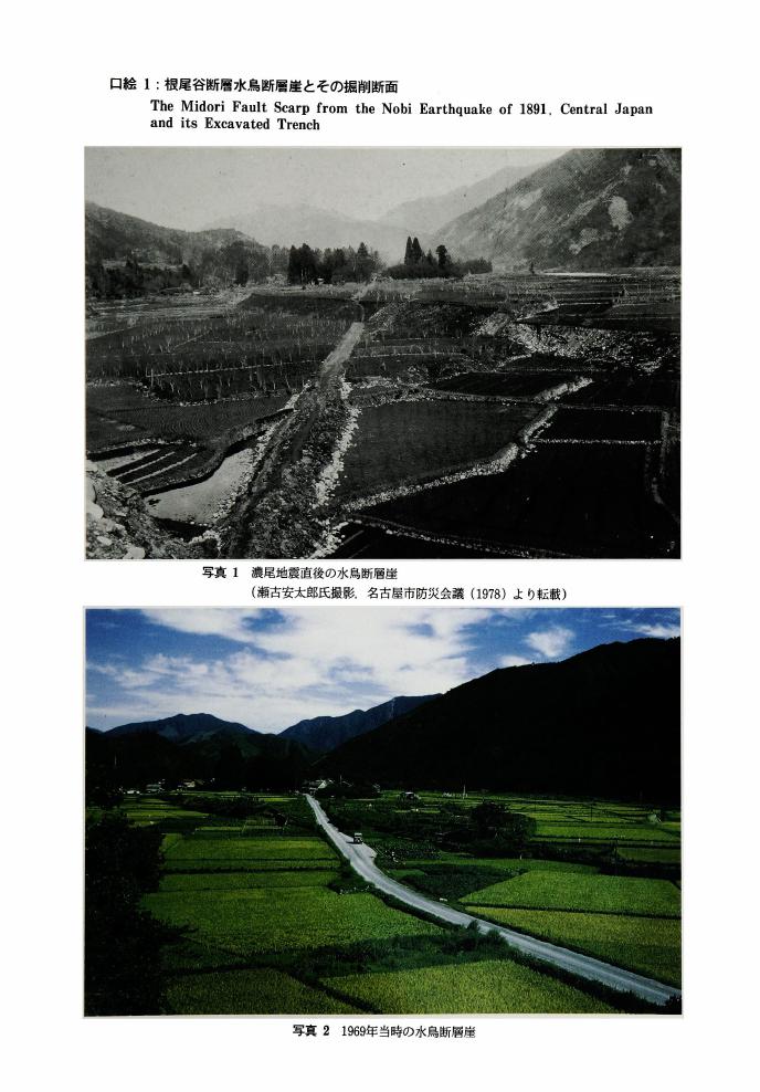
1 0 0 0 OA 根尾谷断層水鳥断層崖とその掘削断面
- 著者
- 佐藤 比呂志 岡田 篤正 松田 時彦 隈元 崇
- 出版者
- 公益社団法人 東京地学協会
- 雑誌
- 地学雑誌 (ISSN:0022135X)
- 巻号頁・発行日
- vol.101, no.7, pp.plate3-plate5, 1992-12-25 (Released:2010-10-13)
1 0 0 0 OA 空中写真による活断層の認定と実例
- 著者
- 松田 時彦 太田 陽子 岡田 篤正 清水 文健 東郷 正美
- 出版者
- 東京大学地震研究所
- 雑誌
- 東京大学地震研究所彙報 (ISSN:00408972)
- 巻号頁・発行日
- vol.52, no.3/4, pp.461-496, 1978-03-31
1 0 0 0 OA 三河湾における深溝断層延長部と中央構造線の音波探査
1 0 0 0 OA 「中部国際空港」海域 (知多半島常滑市沖) の海底地形・地質
- 著者
- 豊蔵 勇 岡田 篤正 牧野内 猛 堀川 義夫 長谷川 淳
- 出版者
- 公益社団法人 東京地学協会
- 雑誌
- 地学雑誌 (ISSN:0022135X)
- 巻号頁・発行日
- vol.108, no.5, pp.589-615, 1999-10-25 (Released:2009-11-12)
- 参考文献数
- 31
- 被引用文献数
- 1 2
Construction of the Chubu International Airport has started off Tokoname City (Chita Peninsula) in Ise Bay. Various surveys such as bathymetry, seafloor drilling, sonic prospecting, and geologic examinations of recovered borehole core samples, have been performed to reveal soil engineering characteristics, submarine topography, and submarine geology at the airport site (Chubu Kuukou Chousakai=The Chubu International Airport Research Foundation, 1994). Many fruitful results on the submarine geology have been obtained in these surveys, as follows : (1) The submarine topography is divided into the inshore “Upper submarine terrace”, “Offshore gently sloping sea floor”, and “Submarine scarp” between the two. A submarine channel is trenched southwards on the inshore submarine terrace.(2) The bay area is underlain by the A, B, C1, C2, and T Formations, in descending order. The T Formation is Mio-Pliocene Tokoname Group, the basement of the bay area. The Tokoname Group forms a buried wave-cut platform of a peninsular shape, which extends southwards. On the east side of the peninsular wave-cut platform, a submarine buried valley stretches southwards under the submarine channel and is mostly filled with the A Formation. On the west side of the wave-cut platform runs the Ise Bay Fault, and the A, B, C1, and C2 Formations thicken offshore.(3) The A Formation, which is divided into the A1 (upper), A2 (middle), and A3 (lower) Members, consists of marine muddy strata of the present bottom surface and is correlated with the Nanyo Formation below the Nohbi Plain (north of the Ise Bay). The A Formation is 25 to 35 meters thick, and the 14C ages range from 9, 400 to 5, 200 y. B.P. of Holocene age.The A3 and A2 Member intercalates the U-Oki and K-Ah tephra, respectively, both are widespread tephra layers in Japan.(4) The B Formation, which is divided into the B1 (upper), B2 (middle), B3 (lower), and B4 (base) Members, consists of sand beds and gravelly beds. The B1, B2, and B3 Members are correlated with the Nohbi and First Gravel Formations below the Nohbi Plain, respectively. The B4 Member forms a buried terrace on the west slope of the peninsular wave-cut platform and is correlated with the Toriimatsu or Ohzone Formations, Lower Terrace Deposits in the eastern margin of the Nohbi Plain. The B Formation is of late Pleistocene age.(5) The C1 Formation consists mainly of marine clay beds about 40 meters thick. The fossil pollen composition indicates that the C1 Formation is correlated with the lower part of the Atsuta Formation in the Nohbi Plain and is of middle Pleistocene age.(6) The C2 Formation consists of sand (upper) and gravelly (lower) beds and exceeds 50 meters thick. The fossil pollen composition indicates that the C2 Formation is correlated with the Ama Formation below the Nohbi Plain and is of middle Pleistocene age.(7) The basement T Formation (Tokoname Group) consists of alternating sand and compact mud beds and intercalates two volcanic ash layers, which are correlated with the Souri (upper, Sr) and Higashitani (lower, Hg) Volcanic Ash Layers from the conformity in index of volcanic glass. The Souri and Higashitani V. A. Ls are intercalated within the upper horizon of the Tokoname Group in the Chita Peninsula.(8) The Ise Bay Fault (faults and flexure zone), trending in the NNW-SSE direction, extends in the western margin of the bay area. The Tokoname Group on the east side of the fault trends northwest and gently dips northeast. The Utsumi Fault, trending in the WNW-ESE dircction, extends in the southern margin of the peninsula.The geological relationship between the Chita Peninsula and airport site in the above-mentioned results brings the following problems for further study.
1 0 0 0 OA 活断層アラカルト (I)
- 著者
- 豊蔵 勇 岡田 篤正
- 出版者
- 一般社団法人日本応用地質学会
- 雑誌
- 応用地質 (ISSN:02867737)
- 巻号頁・発行日
- vol.37, no.2, pp.130-138, 1996-06-10
- 被引用文献数
- 3
兵庫県南部地震と命名されたマグニチュード(以降Mと表す)7.2の都市直下型地震が、1995年1月17日未明の午前5時46分、阪神および淡路島地区を襲い、関東大震災以来の大震災をもたらした(表-1)。兵庫県南部地震は、淡路島北部に分布する野島断層およびその北東延長の活断層が再活動することによって発生したものである。このように、既存の活断層を震源とした直下型地震は、死者5,500名を上回る人的被害をもたらし、復興に要する費用は10兆円を越えると言われている。今回の地震が起きた時刻は、市民の生活がほとんど始まっていない早朝であった。このことは、もう少し遅い時刻で通勤電車、新幹線、高速道路をはじめとする大量輸送機能がフル稼働中であったならば、被害は別の形で大きくなっていた可能性が高く、社会に与えた影響は大きい。今回、活断層に関する解説を担当することとなった岡田は活断層の実態解明に長年携わった研究者として、また豊蔵は活断層調査を耐震設計のコンサルタント業務として携わってきた技術者として、まず活断層についてこれまで蓄積されてきた基本的な知識を整理し、活断層調査の持つ応用地質学的な意味や意義について述べ、さらに今後取り組むべき課題についても若干ふれる。


